IMAGES TAKEN NEAR TO
Egmanton Road, NEWARK, NG22 0LP
Introduction
This page details the photographs taken nearby to Egmanton Road, NG22 0LP by members of the Geograph project.
The Geograph project started in 2005 with the aim of publishing, organising and preserving representative images for every square kilometre of Great Britain, Ireland and the Isle of Man.

There are currently over 7.5m images from over14,400 individuals and you can help contribute to the project by visiting https://www.geograph.org.uk
Image Map
Images are licensed for reuse under creativecommons.org/licenses/by-sa/2.0
Notes
- Clicking on the map will re-center to the selected point.
- The higher the marker number, the further away the image location is from the centre of the postcode.
Image Listing (28 Images Found)
Images are licensed for reuse under creativecommons.org/licenses/by-sa/2.0
Image
Details
Distance
1
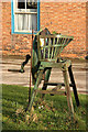
Vintage root cutter
A vintage root cutter re-used as a planter by St.John's College Farm http://www.geograph.org.uk/photo/2278803
Image: © Richard Croft
Taken: 12 Feb 2011
0.03 miles
2
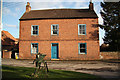
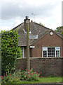
St.John's College Farm
Following the enclosure of Tuxford in 1799, compensation for loss of tithes was paid with land to The Lord of the Manor The Duke of Newcastle, Trinity College and St.John's College, Cambridge. This early 19th century grade II listed farmhouse on Newcastle Street is accompanied by a fine range of contemporary farm buildings, owned by St.John's College.
Image: © Richard Croft
Taken: 12 Feb 2011
0.06 miles
3
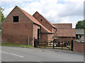
Outbuildings at St John's College Farm
Contemporary with the early 19th century farmhouse http://www.geograph.org.uk/photo/2278803
Image: © Alan Murray-Rust
Taken: 15 Aug 2014
0.06 miles
4
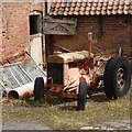
Farmyard bric-a-brac
A decayed stable door, sundry building material and a Fordson Model N from around 1940 which has turned a delicate shade of red to match the brickwork.
Image: © Alan Murray-Rust
Taken: 15 Aug 2014
0.06 miles
5
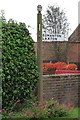
Fingerpost, Newcastle Street
Notts C C octagonal concrete post with slotted arms and octagonal cast-iron finial. This post probably never had more than the single arm, and is simply there to advise motorists not to head straight on into what is only a farm access lane.
Image: © Alan Murray-Rust
Taken: 15 Aug 2014
0.08 miles
6
Direction Sign - Signpost in Tuxford
Octagonal finial - 1 arm; Notts. CC Octagonal concrete, octagonal cast iron finial (NCC) by the UC road, in parish of Tuxford (Bassetlaw District), Newcastle Street, on verge.
Surveyed
Milestone Society National ID: NT_SK7370
Image: © Milestone Society
Taken: Unknown
0.08 miles
7
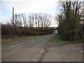
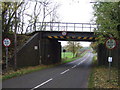
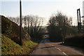
Rail overbridge nr Tuxford
Just out of Tuxford on the Kneesall road is an overbridge which carries the line to High Marnham, which is now back in use as a Network Rail test track for track repair equipment.
Image: © roger geach
Taken: 1 Feb 2010
0.11 miles
10
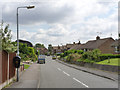
Orchard Crescent, Tuxford
Late 20th century housing development on the south side of the town.
Image: © Alan Murray-Rust
Taken: 15 Aug 2014
0.16 miles