IMAGES TAKEN NEAR TO
Market Place, NEWARK, NG22 0LL
Introduction
This page details the photographs taken nearby to Market Place, NG22 0LL by members of the Geograph project.
The Geograph project started in 2005 with the aim of publishing, organising and preserving representative images for every square kilometre of Great Britain, Ireland and the Isle of Man.

There are currently over 7.5m images from over14,400 individuals and you can help contribute to the project by visiting https://www.geograph.org.uk
Image Map
Images are licensed for reuse under creativecommons.org/licenses/by-sa/2.0
Notes
- Clicking on the map will re-center to the selected point.
- The higher the marker number, the further away the image location is from the centre of the postcode.
Image Listing (139 Images Found)
Images are licensed for reuse under creativecommons.org/licenses/by-sa/2.0
Image
Details
Distance
1
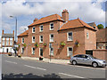
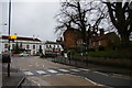
House on the corner of Newark Road
Early 19th century house, recently restored. Previously with modern shop fronts in the left and right bays, and with concrete tiles. Listed Grade II.
Image: © Alan Murray-Rust
Taken: 15 Aug 2014
0.01 miles
2
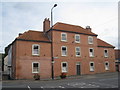
8 and 10 Market Place, Tuxford
Simple late Georgian buildings typical of the small market towns of this area. http://www.britishlistedbuildings.co.uk/en-420407-8-and-10-market-place-tuxford-nottingham
Image: © Jonathan Thacker
Taken: 28 Sep 2012
0.01 miles
3
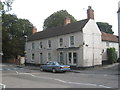
Premises on the corner of Market Place and Newark Road, Tuxford
This appears to have been one of Tuxford's coaching inns. http://www.britishlistedbuildings.co.uk/en-420406-shop-and-domestic-accommodation-occupied
Image: © Jonathan Thacker
Taken: 28 Sep 2012
0.01 miles
5
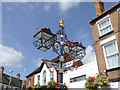
Fingerpost in Tuxford Market Place
Detail of the upper part with the new features referred to here http://www.geograph.org.uk/photo/4126780.
Image: © Alan Murray-Rust
Taken: 15 Aug 2014
0.02 miles
6
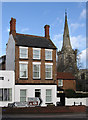
Tuxford - The Tall House and church spire
For an alternative view of The Tall House, please see Image
Image: © Dave Bevis
Taken: 30 Jan 2013
0.02 miles
7
Old Direction Sign - Signpost by the A6075, Market Place, Tuxford
Crown finial - 4 arms; by the A6075, in parish of Tuxford (Bassetlaw District), Market Place, on footway.
Grade II listed.
List Entry Number: 1224351 https://historicengland.org.uk/listing/the-list/list-entry/1224351
Surveyed
Milestone Society National ID: NT_SK7371B
Image: © Milestone Society
Taken: Unknown
0.02 miles
8
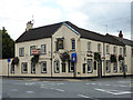
The Sun Inn
Inn on the old Great North Road, faring better than its neighbour The Newcastle Arms http://www.geograph.org.uk/photo/2863177
Image: © Richard Croft
Taken: 29 Aug 2011
0.02 miles
9
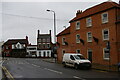
Looking up Lincoln Road to Market Place, Tuxford
Tuxford received a market charter in 1218. It lay on the Great North Road, which passed across the front of the white building on the far side of the Market Place: this, and several other buildings along the main road, were coaching inns, a result of the town's position on the main road north. (The large white building, the former Newcastle Arms, is now an art gallery.)
Image: © Christopher Hilton
Taken: 10 Dec 2019
0.02 miles
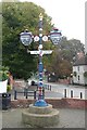
10
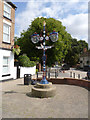
Fingerpost in Tuxford Market Place
Originally built to celebrate the Diamond Jubilee of Queen Victoria in 1897, and refurbished with considerable modification in 2012 to celebrate the equivalent jubilee of Queen Elizabeth II. The original status can be seen in this picture http://www.geograph.org.uk/photo/759976 .
The lamp at the top has been replaced by a crown, and two new large lamps added lower down. Two round plaques fill what were previously open circles next to these lamps which refer to the two Jubilees http://www.geograph.org.uk/photo/4126781. The fingers have been renewed with more ornate ends. Listed Grade II for group value.
Postscript, October 2015:
The 'original' status referred to above is simply the status prior to restoration. The rebuilding has in fact restored the post to its original design.
Image: © Alan Murray-Rust
Taken: 15 Aug 2014
0.02 miles