IMAGES TAKEN NEAR TO
Hagg Lane, NEWARK, NG22 0HJ
Introduction
This page details the photographs taken nearby to Hagg Lane, NG22 0HJ by members of the Geograph project.
The Geograph project started in 2005 with the aim of publishing, organising and preserving representative images for every square kilometre of Great Britain, Ireland and the Isle of Man.

There are currently over 7.5m images from over14,400 individuals and you can help contribute to the project by visiting https://www.geograph.org.uk
Image Map
Images are licensed for reuse under creativecommons.org/licenses/by-sa/2.0
Notes
- Clicking on the map will re-center to the selected point.
- The higher the marker number, the further away the image location is from the centre of the postcode.
Image Listing (12 Images Found)
Images are licensed for reuse under creativecommons.org/licenses/by-sa/2.0
Image
Details
Distance
1
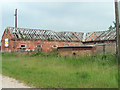
Derelict Building at Common Farm
Another of the farm buildings at Common Farm. This one however appears quite old and quite derelict.
Image: © James Hill
Taken: 9 Jun 2007
0.02 miles
3
Building on Common Farm
A building that appears new yet empty on the land at Common Farm.
Image: © James Hill
Taken: 9 Jun 2007
0.03 miles
4
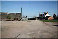
Egmanton Common Farm
Hagg Lane bridleway through Egmanton Common Farm yard
Image: © Richard Croft
Taken: 8 Apr 2011
0.04 miles
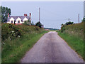
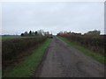
5
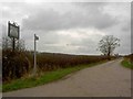
On Hagg Lane
Heading to Edgmanton Common Farm
Image: © Neil Theasby
Taken: 25 May 2020
0.05 miles
6
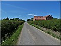
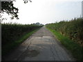
Hagg Lane
View towards Egmanton Common Farm on Hagg Lane
Image: © Richard Croft
Taken: 8 Apr 2011
0.11 miles
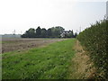
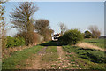
9
Bridleway to Egmanton
Is also the main access to Egmanton Common Farm.
Image: © Jonathan Thacker
Taken: 15 Sep 2016
0.16 miles
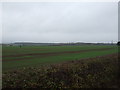
10
Hagg Lane, Private Road and Bridleway
To Egmonton Common Farm.
Image: © Steve Fareham
Taken: 13 Mar 2009
0.19 miles