IMAGES TAKEN NEAR TO
Burnmoor Lane, NEWARK, NG22 0HE
Introduction
This page details the photographs taken nearby to Burnmoor Lane, NG22 0HE by members of the Geograph project.
The Geograph project started in 2005 with the aim of publishing, organising and preserving representative images for every square kilometre of Great Britain, Ireland and the Isle of Man.

There are currently over 7.5m images from over14,400 individuals and you can help contribute to the project by visiting https://www.geograph.org.uk
Image Map
Images are licensed for reuse under creativecommons.org/licenses/by-sa/2.0
Notes
- Clicking on the map will re-center to the selected point.
- The higher the marker number, the further away the image location is from the centre of the postcode.
Image Listing (85 Images Found)
Images are licensed for reuse under creativecommons.org/licenses/by-sa/2.0
Image
Details
Distance
3
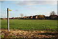
Footpath in Egmanton
This is a very short path (its complete length is visible in this picture) that runs from near the church and Village Hall (the former school) to Weston Road. It takes only a matter of seconds longer to go round via the road and at this time of the year is rather less muddy!
Image: © Jonathan Thacker
Taken: 14 Jan 2011
0.13 miles
5
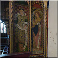
Church of Our Lady of Egmanton, Egmanton
The prophet Ezekiel and St John the Divine on the south side of the screen.
Image: © Alan Murray-Rust
Taken: 1 Aug 2014
0.16 miles
6
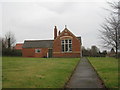
Egmanton Village Hall
The former school.
Image: © Jonathan Thacker
Taken: 14 Jan 2011
0.16 miles
7

Egmanton Village Hall
Built in 1899 as the village school.
Image: © Alan Murray-Rust
Taken: 8 Aug 2014
0.16 miles
8

Egmanton cemetery
Looking east along the narrow strip of land which supplements the original churchyard on the other side of Main Street.
Image: © Trevor Rickard
Taken: 8 Jul 2012
0.16 miles
9
Egmanton
Footpath from St.Mary's church to Weston Road
Image: © Richard Croft
Taken: 12 Feb 2011
0.17 miles
10
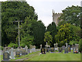
Cemetery, Egmanton
Created as an extension to the churchyard on the opposite side of Tuxford Road.
Image: © Alan Murray-Rust
Taken: 8 Aug 2014
0.17 miles