IMAGES TAKEN NEAR TO
Eakring Road, NEWARK, NG22 0ED
Introduction
This page details the photographs taken nearby to Eakring Road, NG22 0ED by members of the Geograph project.
The Geograph project started in 2005 with the aim of publishing, organising and preserving representative images for every square kilometre of Great Britain, Ireland and the Isle of Man.

There are currently over 7.5m images from over14,400 individuals and you can help contribute to the project by visiting https://www.geograph.org.uk
Image Map
Images are licensed for reuse under creativecommons.org/licenses/by-sa/2.0
Notes
- Clicking on the map will re-center to the selected point.
- The higher the marker number, the further away the image location is from the centre of the postcode.
Image Listing (7 Images Found)
Images are licensed for reuse under creativecommons.org/licenses/by-sa/2.0
Image
Details
Distance
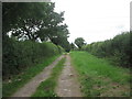
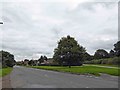
3
Country track heading north to Wellow
With crisscrossing electricity cables partly spoiling the scene as they often tend to do.
Image: © Neil Theasby
Taken: 25 Feb 2022
0.17 miles
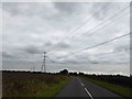
7
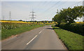
Under the Pylons
On the Wellow to Eakring road.
Image: © roger geach
Taken: 4 May 2011
0.23 miles