IMAGES TAKEN NEAR TO
Highbury Green, NEWARK, NG22 0BU
Introduction
This page details the photographs taken nearby to Highbury Green, NG22 0BU by members of the Geograph project.
The Geograph project started in 2005 with the aim of publishing, organising and preserving representative images for every square kilometre of Great Britain, Ireland and the Isle of Man.

There are currently over 7.5m images from over14,400 individuals and you can help contribute to the project by visiting https://www.geograph.org.uk
Image Map
Images are licensed for reuse under creativecommons.org/licenses/by-sa/2.0
Notes
- Clicking on the map will re-center to the selected point.
- The higher the marker number, the further away the image location is from the centre of the postcode.
Image Listing (65 Images Found)
Images are licensed for reuse under creativecommons.org/licenses/by-sa/2.0
Image
Details
Distance
1
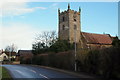
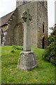
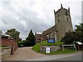
St Andrew's Church, Eakring, Notts.
The Grade II* listed Parish Church on the east side of Kirklington Road is seen here on the approach into the centre of the village. The current building dates back to the C13th, the oldest part being the tower which has a C13th base and a C15th top storey. The building was restored in Elizabethan times, next in the C17th century on the instruction of the Rev. William Mompesson, who widened the nave and added the two porches, and then again in 1881.
Image: © David Hallam-Jones
Taken: 16 Jan 2015
0.07 miles
2
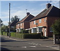
Houses on Triumph Road, Eakring
A village side street.
Image: © Andrew Hill
Taken: 8 Sep 2012
0.07 miles
4
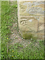
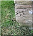
Bench mark, St Andrew's Church, Eakring
See http://www.geograph.org.uk/photo/4024521 for location.
Image: © Alan Murray-Rust
Taken: 1 Jun 2014
0.09 miles
5
Cut bench mark on Eakring, St Andrew's Church
Cut bench mark at the NW angle of the tower. See http://www.bench-marks.org.uk/bm37679 for details.
Image: © Brian Westlake
Taken: 23 Apr 2011
0.09 miles
6
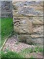
Ordnance Survey Cut Mark
This OS cut mark can be found on the west face of St Andrew's Church. It marks a point 74.225m above mean sea level.
Image: © Adrian Dust
Taken: 28 May 2016
0.09 miles
7
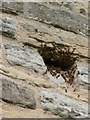
Bees in the belfry
These bees had clearly established a nest inside the tower and were entering through several of the scaffold holes on the west face http://www.geograph.org.uk/photo/4024539.
Image: © Alan Murray-Rust
Taken: 1 Jun 2014
0.09 miles
9
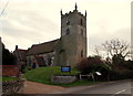
St Andrew's Church, Eakring, Notts.
This Grade II* listed gem is seen here from the junction with Church Lane opposite. The Rev. Wm Mompesson (1639-1709) was ordained in 1660 and became Domestic Chaplain to Sir George Savile of Rufford. Following this he was given a curacy at Wellow by Sir George, was married in 1662 and in due course he and his wife had two children. In 1663 he acquired the better 'living' of Bilsthorpe, Notts. and soon after was offered the living of Eyam, Derbyshire which was also in the gift of Savile. The Mompessons arrived there in 1664, but the following year the village of Eyam was struck by bubonic plague. The plague accounted for about 260 deaths of the village, including Mompesson's wife. During the plague, Mompesson organised the isolation of Eyam, something that resulted in more deaths within the village but halted the spread of the plague to other villages. In 1669, he married a widow who had been a neighbour at Wellow and in the same year was offered the living of Eakring by Savile when it became vacant. He was installed as Rector of Eakring in January 1671.
Image: © David Hallam-Jones
Taken: 16 Jan 2015
0.09 miles