IMAGES TAKEN NEAR TO
Maplebeck, NEWARK, NG22 0BS
Introduction
This page details the photographs taken nearby to NG22 0BS by members of the Geograph project.
The Geograph project started in 2005 with the aim of publishing, organising and preserving representative images for every square kilometre of Great Britain, Ireland and the Isle of Man.

There are currently over 7.5m images from over14,400 individuals and you can help contribute to the project by visiting https://www.geograph.org.uk
Image Map
Images are licensed for reuse under creativecommons.org/licenses/by-sa/2.0
Notes
- Clicking on the map will re-center to the selected point.
- The higher the marker number, the further away the image location is from the centre of the postcode.
Image Listing (45 Images Found)
Images are licensed for reuse under creativecommons.org/licenses/by-sa/2.0
Image
Details
Distance
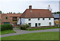
1
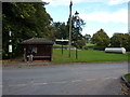
Maplebeck bus shelter
With village green and old road sign; to Newark and Mansfield.
Image: © Peter Barr
Taken: 8 Oct 2013
0.01 miles
2
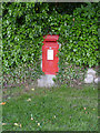
Maplebeck postbox ref NG22 50
Standard EIIR wall box. Clearly a replacement for an earlier box, the location having been in use since Victorian times, marked on old OS maps.
Image: © Alan Murray-Rust
Taken: 1 Jun 2014
0.01 miles
3
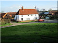
Low Farmhouse, Maplebeck
Recent research dates this to the late sixteenth century https://historicengland.org.uk/listing/the-list/list-entry/1370159?section=official-list-entry
Image: © Jonathan Thacker
Taken: 21 Feb 2022
0.01 miles
5
Low Farmhouse, Maplebeck
The whitewashed render conceals a 17th century timber framed building, with 19th century additions and a 20th century pantiled roof. Listed Grade II.
Image: © Alan Murray-Rust
Taken: 1 Jun 2014
0.02 miles
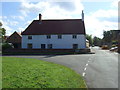
6
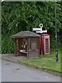
Maplebeck, Bus shelter, fingerpost and telephone kiosk
The village currently (2014) gets just two return bus journeys per week, one to Newark and one to Southwell. The fingerpost is an unusual amalgam of the traditional cast iron annulus finial and finger brackets on a simple modern tubular steel post. The K6 telephone kiosk retains a phone and is also accorded Listed Grade II status.
Image: © Alan Murray-Rust
Taken: 1 Jun 2014
0.02 miles
8
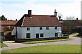
Low Farmhouse
16th century timber-framed farmhouse in Maplebeck
Image: © Richard Croft
Taken: 18 Mar 2011
0.03 miles
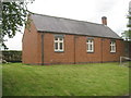
9
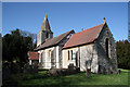
St. Radegund's church
Largely 13th & 14th century church, restored by Hodgson Fowler in 1898
One of only 5 churches dedicated to St. Radegund, a 6th century German princess. The others are at Grayingham http://www.geograph.org.uk/photo/50481 Scruton http://www.geograph.org.uk/photo/636556 Postling http://www.geograph.org.uk/photo/2069595 and Whitwell http://www.geograph.org.uk/photo/118575
Image: © Richard Croft
Taken: 18 Mar 2011
0.03 miles
10
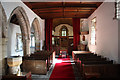
St.Radegund's church interior
The nave, looking east, with an early 14th century north arcade
Image: © Richard Croft
Taken: 18 Mar 2011
0.03 miles