IMAGES TAKEN NEAR TO
Newark Road, NEWARK, NG22 0BN
Introduction
This page details the photographs taken nearby to Newark Road, NG22 0BN by members of the Geograph project.
The Geograph project started in 2005 with the aim of publishing, organising and preserving representative images for every square kilometre of Great Britain, Ireland and the Isle of Man.

There are currently over 7.5m images from over14,400 individuals and you can help contribute to the project by visiting https://www.geograph.org.uk
Image Map
Images are licensed for reuse under creativecommons.org/licenses/by-sa/2.0
Notes
- Clicking on the map will re-center to the selected point.
- The higher the marker number, the further away the image location is from the centre of the postcode.
Image Listing (12 Images Found)
Images are licensed for reuse under creativecommons.org/licenses/by-sa/2.0
Image
Details
Distance
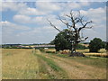
1
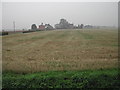
Eakring Field Farm
viewed south from the road
Image: © Tom Courtney
Taken: 6 Oct 2005
0.03 miles
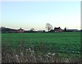
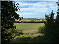
3
Eakring Field Farm
from the footpath between Maplebeck and Eakring
Image: © Richard Croft
Taken: Unknown
0.09 miles
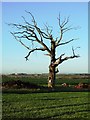
4
Eakring Field Farm (2)
Seen from Hagley's Dumble.
Image: © Peter Barr
Taken: 8 Oct 2013
0.09 miles
6
Eakring Field Farm
Seen from Parkhill Plantation, on a path from Maplebeck to Eakring.
Image: © Peter Barr
Taken: 8 Oct 2013
0.12 miles
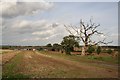
7
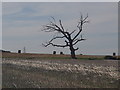
Stubble and dead tree near Eakring Field Farm
Farmland view from the footpath passing to the south of the farm.
Image: © Andrew Hill
Taken: 8 Sep 2012
0.14 miles
9
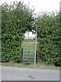
Hole in the hedge
Footpath to Penny Pasture Nature Reserve
Image: © J.Hannan-Briggs
Taken: 2 Oct 2011
0.17 miles
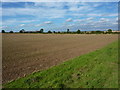
10
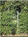
Footpath to Kneesall
Summer hedge growth has almost obscured the beginning of this path.
Image: © Jonathan Thacker
Taken: 4 Oct 2018
0.17 miles