IMAGES TAKEN NEAR TO
Kneesall, NEWARK, NG22 0AW
Introduction
This page details the photographs taken nearby to NG22 0AW by members of the Geograph project.
The Geograph project started in 2005 with the aim of publishing, organising and preserving representative images for every square kilometre of Great Britain, Ireland and the Isle of Man.

There are currently over 7.5m images from over14,400 individuals and you can help contribute to the project by visiting https://www.geograph.org.uk
Image Map
Images are licensed for reuse under creativecommons.org/licenses/by-sa/2.0
Notes
- Clicking on the map will re-center to the selected point.
- The higher the marker number, the further away the image location is from the centre of the postcode.
Image Listing (4 Images Found)
Images are licensed for reuse under creativecommons.org/licenses/by-sa/2.0
Image
Details
Distance
4
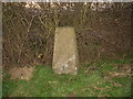
Lound Wood Triangulation Pillar
Set into field side rather than the wood itself which is several hundred yards to the south-east.
Image: © Peter Wood
Taken: 4 Mar 2014
0.24 miles