IMAGES TAKEN NEAR TO
Flash Lane, NEWARK, NG22 0AT
Introduction
This page details the photographs taken nearby to Flash Lane, NG22 0AT by members of the Geograph project.
The Geograph project started in 2005 with the aim of publishing, organising and preserving representative images for every square kilometre of Great Britain, Ireland and the Isle of Man.

There are currently over 7.5m images from over14,400 individuals and you can help contribute to the project by visiting https://www.geograph.org.uk
Image Map
Images are licensed for reuse under creativecommons.org/licenses/by-sa/2.0
Notes
- Clicking on the map will re-center to the selected point.
- The higher the marker number, the further away the image location is from the centre of the postcode.
Image Listing (16 Images Found)
Images are licensed for reuse under creativecommons.org/licenses/by-sa/2.0
Image
Details
Distance
2
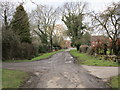
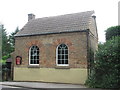
Ompton Village looking NW
A view, NW through Ompton Village.
Image: © James Hill
Taken: 28 Jul 2007
0.03 miles
6
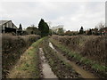
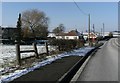
Flash Lane, Ompton
It's been a wet winter!
Image: © Jonathan Thacker
Taken: 23 Feb 2018
0.07 miles
7
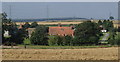
Ompton from field by Shortwood Farm
View over the grid line of the little rural village.
Image: © Andrew Hill
Taken: 8 Sep 2012
0.08 miles
9
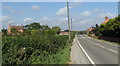
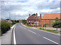
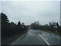
A616 through Ompton
Ompton is a small village on the road between Kneesall and Wellow.
Image: © Andrew Hill
Taken: 8 Sep 2012
0.09 miles
10
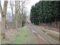
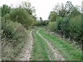
Bridleway and the farmyard at Home Farm, Ompton
Image: © Jonathan Thacker
Taken: 23 Feb 2018
0.12 miles