IMAGES TAKEN NEAR TO
Kneesall, NEWARK, NG22 0AN
Introduction
This page details the photographs taken nearby to NG22 0AN by members of the Geograph project.
The Geograph project started in 2005 with the aim of publishing, organising and preserving representative images for every square kilometre of Great Britain, Ireland and the Isle of Man.

There are currently over 7.5m images from over14,400 individuals and you can help contribute to the project by visiting https://www.geograph.org.uk
Image Map
Images are licensed for reuse under creativecommons.org/licenses/by-sa/2.0
Notes
- Clicking on the map will re-center to the selected point.
- The higher the marker number, the further away the image location is from the centre of the postcode.
Image Listing (21 Images Found)
Images are licensed for reuse under creativecommons.org/licenses/by-sa/2.0
Image
Details
Distance
1
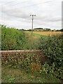
View towards North Laiths
Taken from the site of the former railway bridge.
Image: © Jonathan Thacker
Taken: 16 Dec 2011
0.01 miles
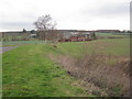
2
North Laiths
A group of buildings on the northern edge of the square. The track is a public footpath which joins the long distance Robin Hood Way just beyond the buildings.
Image: © Lynne Kirton
Taken: 25 Feb 2007
0.04 miles
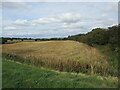
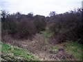
4
The course of the Mid Nottinghamshire Joint Railway
The Mid-Nottinghamshire Joint Railway opened in 1931 and this section closed in 1966. As planned the railway would have run along the spine of Nottinghamshire linking the collieries on the eastern edge of the coalfield with the various main lines. The line was never completed and only really served the colliery at Bilsthorpe (and to a lesser extent that at Ollerton).
Here the track bed is overgrown and the bridge, which stood at the point from which this photograph was taken, has been infilled.
Image: © Jonathan Thacker
Taken: 13 Sep 2021
0.09 miles
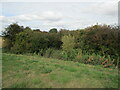
6
Course of dismantled railway
One of the old mineral lines which served the area's coal mines. See also Image for a section of the line in nearby Clipstone Forest.
Image: © Lynne Kirton
Taken: 25 Feb 2007
0.10 miles
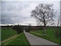
7
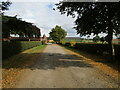
Roadway at North Laiths
The Pigeoncote https://historicengland.org.uk/listing/the-list/list-entry/1178695 is visible in the centre of the picture.
Image: © Jonathan Thacker
Taken: 13 Sep 2021
0.14 miles
8
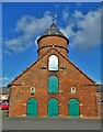
Building at North Laiths Farm
A distinctive brick built dovecote with kennelling below
Image: © Neil Theasby
Taken: 25 Feb 2022
0.15 miles
9
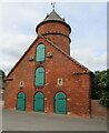
Pigeoncote and kennels at North Laiths
Listed Grade II https://historicengland.org.uk/listing/the-list/list-entry/1178695
Image: © Jonathan Thacker
Taken: 13 Sep 2021
0.15 miles
10
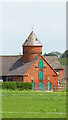
Dovecote and barn at North Laiths Farm, Rufford
The dovecote is Grade II listed.
Image: © Colin Park
Taken: 27 May 2021
0.15 miles