IMAGES TAKEN NEAR TO
Ashville Close, NOTTINGHAM, NG2 1LL
Introduction
This page details the photographs taken nearby to Ashville Close, NG2 1LL by members of the Geograph project.
The Geograph project started in 2005 with the aim of publishing, organising and preserving representative images for every square kilometre of Great Britain, Ireland and the Isle of Man.

There are currently over 7.5m images from over14,400 individuals and you can help contribute to the project by visiting https://www.geograph.org.uk
Image Map
Images are licensed for reuse under creativecommons.org/licenses/by-sa/2.0
Notes
- Clicking on the map will re-center to the selected point.
- The higher the marker number, the further away the image location is from the centre of the postcode.
Image Listing (67 Images Found)
Images are licensed for reuse under creativecommons.org/licenses/by-sa/2.0
Image
Details
Distance
1
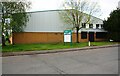
Ashville Close Units, Longwall Avenue, Queens Drive Industrial Estate
There is an Ordnance Survey benchmark Image on the building at its left hand corner
Image: © Luke Shaw
Taken: 11 May 2019
0.02 miles
2
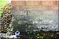
Benchmark on industrial units, Longwall Avenue
Ordnance Survey cut mark benchmark described on the Bench Mark Database at www.bench-marks.org.uk/bm112064
Image: © Luke Shaw
Taken: 11 May 2019
0.03 miles
3
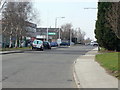
Longwall Avenue
On Lenton Industrial Estate
Image: © Alan Murray-Rust
Taken: 20 Mar 2009
0.05 miles
4
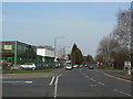
Crossgate Drive
Spine road of Lenton Industrial Estate.
Image: © Alan Murray-Rust
Taken: 20 Mar 2009
0.13 miles
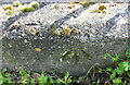
5
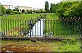
River Leen at King's Meadow
There is an Ordnance Survey benchmark Image on top of the concrete culvert over the right hand bank of the river
Image: © Luke Shaw
Taken: 11 May 2019
0.15 miles
6
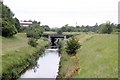
River Leen alongside Birdcage Walk
This part of the course of the Leen was not created until the late 1960s/1970s as part of flood alleviation schemes. The bridge originally carried rail sidings into Wilford Power Station and Clifton Colliery.
Image: © Alan Murray-Rust
Taken: 21 Jun 2012
0.15 miles
7
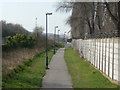
Birdcage Walk
Alongside the River Leen (behind the bank to the left), now a significant cycle route.
Image: © Alan Murray-Rust
Taken: 20 Mar 2009
0.15 miles
8
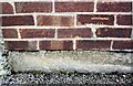
Benchmark on FedEx building, Crossgate Drive
Ordnance Survey cut mark benchmark described on the Bench Mark Database at www.bench-marks.org.uk/bm112063
Image: © Luke Shaw
Taken: 11 May 2019
0.15 miles
9
Benchmark on culvert over River Leen
Ordnance Survey rivet benchmark described on the Bench Mark Database at www.bench-marks.org.uk/bm114988
Image: © Luke Shaw
Taken: 11 May 2019
0.15 miles
10

FedEx building, Crossgate Drive
There is an Ordnance Survey benchmark Image on the right hand corner, right hand face, of the building
Image: © Luke Shaw
Taken: 11 May 2019
0.16 miles