IMAGES TAKEN NEAR TO
Strome Court, NOTTINGHAM, NG2 1HG
Introduction
This page details the photographs taken nearby to Strome Court, NG2 1HG by members of the Geograph project.
The Geograph project started in 2005 with the aim of publishing, organising and preserving representative images for every square kilometre of Great Britain, Ireland and the Isle of Man.

There are currently over 7.5m images from over14,400 individuals and you can help contribute to the project by visiting https://www.geograph.org.uk
Image Map
Images are licensed for reuse under creativecommons.org/licenses/by-sa/2.0
Notes
- Clicking on the map will re-center to the selected point.
- The higher the marker number, the further away the image location is from the centre of the postcode.
Image Listing (356 Images Found)
Images are licensed for reuse under creativecommons.org/licenses/by-sa/2.0
Image
Details
Distance
1
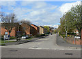
A touch of uncertainty
According to the street name signs, the left hand side is Launder Street, the right hand side is Launders Street. Maps all appear to show it as Launder Street.
Image: © Alan Murray-Rust
Taken: 7 Apr 2009
0.02 miles
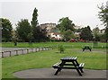
2
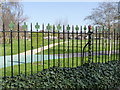
Queens Walk Recreation Ground
The sign for the park in the Nottingham City Council corporate green merges into the background.
The railings incorporate cast finials depicting the City's shield; some of the arrowheads are modern replacements for damaged original cast iron ones.
Image: © Alan Murray-Rust
Taken: 1 Apr 2012
0.02 miles
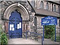
3
Queen's Walk Recreation Ground and St George's Church
"By R C Sutton, 1887-91; chancel by Bodley, 1897, tall and plain, with a very tall separate altar niche possessing only one window high up, an impressive composition" (Nikolaus Pevsner).
Image: © John Sutton
Taken: 12 Sep 2012
0.03 miles
4
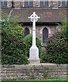
The Meadows: war memorial at St George's Church
"To the Glory of God and in memory of the men of St George's Parish who gave their lives for home and country in the wars of 1914-1918 and 1939-1945." The calvary dates from 1921 and is by Pask & Thorpe.
Image: © John Sutton
Taken: 12 Sep 2012
0.03 miles
5
The Meadows: St George's Church porch
A Tractarian church whose foundation stone is dated 1887. The nave is the work of the Nottingham architect R C Sutton; later aspects are by G F Bodley and others.
Image: © John Sutton
Taken: 12 Sep 2012
0.04 miles
6
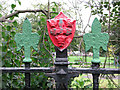
A reminder of the Borough
The iron railings round Queen's Walk Recreation Ground are topped by fleurs-de-lys and shields with the ragged cross and three crowns of the Borough of Nottingham. The red shield became the centrepiece of the Nottingham coat of arms after city status was conferred in 1897.
Image: © John Sutton
Taken: 12 Sep 2012
0.04 miles
7
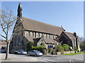
St George's Church, The Meadows, Nottingham
Late Victorian parish church which survived the redevelopment of The Meadows in the 1970s. Services are in the Anglo-Catholic tradition celebrating Mass rather than Holy Communion. Built 1887-1891 to the design of R. C. Sutton, the south chapel is later. Listed Grade II, the listing includes the boundary wall.
Image: © Alan Murray-Rust
Taken: 1 Apr 2012
0.04 miles
8
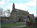
St George's in the Meadows
Victorian parish church built 1887-1891 to the design of R. C. Sutton.
Image: © Alan Murray-Rust
Taken: 7 Apr 2009
0.06 miles
9
Our Lady and St Patrick
Catholic church in the Meadows
Image: © Alan Murray-Rust
Taken: 7 Apr 2009
0.06 miles
10
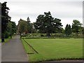
Queen's Walk Recreation Ground
Castle Rock and Nottingham Castle on the skyline in the centre, nasty high-rise around Maid Marian Way to the right.
Image: © John Sutton
Taken: 12 Sep 2012
0.06 miles