IMAGES TAKEN NEAR TO
Wilford Road, NOTTINGHAM, NG2 1EB
Introduction
This page details the photographs taken nearby to Wilford Road, NG2 1EB by members of the Geograph project.
The Geograph project started in 2005 with the aim of publishing, organising and preserving representative images for every square kilometre of Great Britain, Ireland and the Isle of Man.

There are currently over 7.5m images from over14,400 individuals and you can help contribute to the project by visiting https://www.geograph.org.uk
Image Map
Images are licensed for reuse under creativecommons.org/licenses/by-sa/2.0
Notes
- Clicking on the map will re-center to the selected point.
- The higher the marker number, the further away the image location is from the centre of the postcode.
Image Listing (814 Images Found)
Images are licensed for reuse under creativecommons.org/licenses/by-sa/2.0
Image
Details
Distance
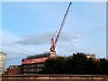
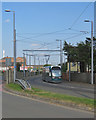
2
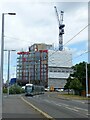
The Vantage, Queens Drive
Yet another block of student residences rises into the Nottingham skyline. These days it seems that every second construction site is student residences, but it reflects the presence of two large universities and a large further education college in the city.
In the foreground NET tram 221 passes along Meadows Way West on its way to Hucknall.
Image: © Alan Murray-Rust
Taken: 29 Jul 2021
0.02 miles
3
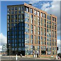
Nottingham New Build 2022 ? 11
'The Vantage'. New student residences at the junction of Wilford Street and Waterway Street.
Image: © Alan Murray-Rust
Taken: 23 Sep 2022
0.03 miles
4
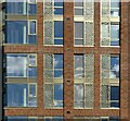
Clouds and lace
Detail of 'The Vantage' - see https://www.geograph.org.uk/photo/7295030 for location; the grilles are inspired by Nottingham lace.
Image: © Alan Murray-Rust
Taken: 23 Sep 2022
0.03 miles
5
Redgate student accommodation under construction
A block of "premium accommodation" for 297 students due to open in time for academic year 2024/25.
Image: © Ian Calderwood
Taken: 4 Oct 2023
0.03 miles
6
Wilford Road, Meadows Way and a little bit of history
Looking back towards Waterway Street and the city from a corner of Meadows Way, one of the new roads created when the Victorian terraced streets of The Meadows were cleared in the 1970s. The rusty cast-iron object in the foreground is a relic of Nottingham's twentieth-century tram and trolleybus systems and I was quite surprised to find it still here. For more about it, see Image
Image: © John Sutton
Taken: 15 Jul 2019
0.03 miles
8
Protective barrier on Meadows Way West
The provision of a vehicle guard barrier in a purely urban environment is very unusual, but here there is only a very narrow space between this carriageway and Waterway Street, where traffic is travelling in the opposite direction.
Image: © Alan Murray-Rust
Taken: 20 Mar 2015
0.04 miles
9
A Toton Lane tram on Meadows Way
The road system hereabouts dates from the redevelopment of The Meadows in the 1970s, when Victorian terraced streets were swept away. This part of Meadows Way runs parallel to Waterway Street West.
Image: © John Sutton
Taken: 15 Jul 2019
0.04 miles
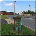
10
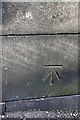
Benchmark on Wilford Road railway bridge parapet
Ordnance Survey cut mark benchmark described on the Bench Mark Database at http://www.bench-marks.org.uk/bm34401
Image: © Roger Templeman
Taken: 8 Apr 2012
0.04 miles