IMAGES TAKEN NEAR TO
Cavendish Avenue, MANSFIELD, NG21 9NQ
Introduction
This page details the photographs taken nearby to Cavendish Avenue, NG21 9NQ by members of the Geograph project.
The Geograph project started in 2005 with the aim of publishing, organising and preserving representative images for every square kilometre of Great Britain, Ireland and the Isle of Man.

There are currently over 7.5m images from over14,400 individuals and you can help contribute to the project by visiting https://www.geograph.org.uk
Image Map
Images are licensed for reuse under creativecommons.org/licenses/by-sa/2.0
Notes
- Clicking on the map will re-center to the selected point.
- The higher the marker number, the further away the image location is from the centre of the postcode.
Image Listing (7 Images Found)
Images are licensed for reuse under creativecommons.org/licenses/by-sa/2.0
Image
Details
Distance
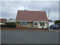
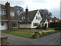
4

The Manvers Arms
A pub on Mansfield Road, and Welbeck Drive.
Image: © Peter Barr
Taken: 16 Aug 2013
0.11 miles
5
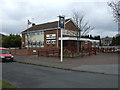
The Manvers Arms pub, Edwinstowe
On Mansfield Road (A6075).
Image: © JThomas
Taken: 17 Mar 2014
0.11 miles
7
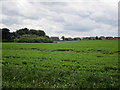
The edge of Edwinstowe
Looking across a field of carrots.
Image: © Jonathan Thacker
Taken: 4 Jul 2014
0.20 miles