IMAGES TAKEN NEAR TO
Mansfield Road, MANSFIELD, NG21 9NP
Introduction
This page details the photographs taken nearby to Mansfield Road, NG21 9NP by members of the Geograph project.
The Geograph project started in 2005 with the aim of publishing, organising and preserving representative images for every square kilometre of Great Britain, Ireland and the Isle of Man.

There are currently over 7.5m images from over14,400 individuals and you can help contribute to the project by visiting https://www.geograph.org.uk
Image Map
Images are licensed for reuse under creativecommons.org/licenses/by-sa/2.0
Notes
- Clicking on the map will re-center to the selected point.
- The higher the marker number, the further away the image location is from the centre of the postcode.
Image Listing (10 Images Found)
Images are licensed for reuse under creativecommons.org/licenses/by-sa/2.0
Image
Details
Distance
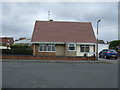
1
The Manvers Arms pub, Edwinstowe
On Mansfield Road (A6075).
Image: © JThomas
Taken: 17 Mar 2014
0.07 miles
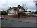
2

The Manvers Arms
A pub on Mansfield Road, and Welbeck Drive.
Image: © Peter Barr
Taken: 16 Aug 2013
0.08 miles
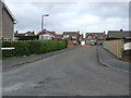
3
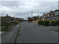
I remember when all of this was school
Now a new estate, the old Rufford School site has been re-developed.
Image: © James Hill
Taken: 9 Jun 2007
0.11 miles
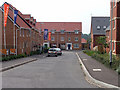
4
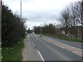
Mansfield Road (A6075), Edwinstowe
Heading east.
Image: © JThomas
Taken: 17 Mar 2014
0.13 miles
7
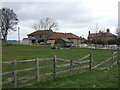
Grazing, Villa Real Farm
North of the A6075.
Image: © JThomas
Taken: 17 Mar 2014
0.23 miles
8
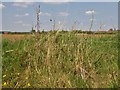
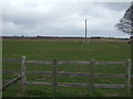
What's over there?
Hold camera up high above grassy bank and what do we see? Not a lot, but Edwinstowe beyond the field!
Image: © Chris Morgan
Taken: 7 May 2013
0.23 miles