IMAGES TAKEN NEAR TO
Mansfield Road, MANSFIELD, NG21 9HF
Introduction
This page details the photographs taken nearby to Mansfield Road, NG21 9HF by members of the Geograph project.
The Geograph project started in 2005 with the aim of publishing, organising and preserving representative images for every square kilometre of Great Britain, Ireland and the Isle of Man.

There are currently over 7.5m images from over14,400 individuals and you can help contribute to the project by visiting https://www.geograph.org.uk
Image Map
Images are licensed for reuse under creativecommons.org/licenses/by-sa/2.0
Notes
- Clicking on the map will re-center to the selected point.
- The higher the marker number, the further away the image location is from the centre of the postcode.
Image Listing (3 Images Found)
Images are licensed for reuse under creativecommons.org/licenses/by-sa/2.0
Image
Details
Distance
1
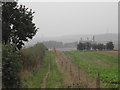
Public Footpath
this path runs SW from the forest towards the Edwinstowe road, coming out near Villa Real Farm
Image: © Tom Courtney
Taken: 8 Oct 2005
0.07 miles
2
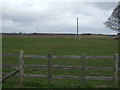
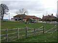
Grazing, Villa Real Farm
North of the A6075.
Image: © JThomas
Taken: 17 Mar 2014
0.20 miles