IMAGES TAKEN NEAR TO
Gardeners Way, MANSFIELD, NG21 9HB
Introduction
This page details the photographs taken nearby to Gardeners Way, NG21 9HB by members of the Geograph project.
The Geograph project started in 2005 with the aim of publishing, organising and preserving representative images for every square kilometre of Great Britain, Ireland and the Isle of Man.

There are currently over 7.5m images from over14,400 individuals and you can help contribute to the project by visiting https://www.geograph.org.uk
Image Map
Images are licensed for reuse under creativecommons.org/licenses/by-sa/2.0
Notes
- Clicking on the map will re-center to the selected point.
- The higher the marker number, the further away the image location is from the centre of the postcode.
Image Listing (8 Images Found)
Images are licensed for reuse under creativecommons.org/licenses/by-sa/2.0
Image
Details
Distance
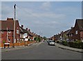
1

View towards Clipstone Colliery headstocks
Grade 2 listed buildings
Image: © Chris Morgan
Taken: 3 Oct 2017
0.05 miles
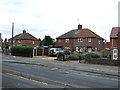
2
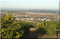
New Clipstone from the south
The view from the old colliery waste tip, now a Country Park. Despite the closure of the colliery there has been a considerable amount of new housing development.
Image: © Alan Murray-Rust
Taken: 23 Dec 2007
0.10 miles
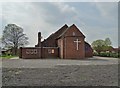
6
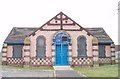
Methodist Church, Clipstone
Upon Church Road, Clipstone
Image: © Geoff Dunn
Taken: 4 Feb 2006
0.21 miles
7
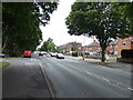
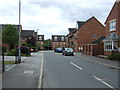
Mansfield Road (B6030)
Heading west through Clipstone.
Image: © JThomas
Taken: 7 Sep 2013
0.22 miles