IMAGES TAKEN NEAR TO
Church Road, MANSFIELD, NG21 9GJ
Introduction
This page details the photographs taken nearby to Church Road, NG21 9GJ by members of the Geograph project.
The Geograph project started in 2005 with the aim of publishing, organising and preserving representative images for every square kilometre of Great Britain, Ireland and the Isle of Man.

There are currently over 7.5m images from over14,400 individuals and you can help contribute to the project by visiting https://www.geograph.org.uk
Image Map
Images are licensed for reuse under creativecommons.org/licenses/by-sa/2.0
Notes
- Clicking on the map will re-center to the selected point.
- The higher the marker number, the further away the image location is from the centre of the postcode.
Image Listing (13 Images Found)
Images are licensed for reuse under creativecommons.org/licenses/by-sa/2.0
Image
Details
Distance
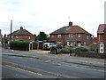
3
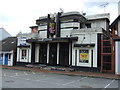
The Ritz (and Olympic Sports Bar), Clipstone
Image: © JThomas
Taken: 7 Sep 2013
0.14 miles
5
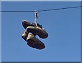
Two pairs of shoes
Why they were hanging high above the road from the telegraph wire was a story we never heard.
Image: © Chris Morgan
Taken: 3 Oct 2017
0.18 miles
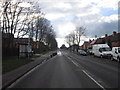
6
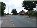
Mansfield Road (B6030)
Heading west through Clipstone.
Image: © JThomas
Taken: 7 Sep 2013
0.21 miles
9
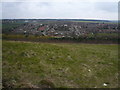
Vicar Water Country Park - Hill view of Clipstone
Image: © Alan Heardman
Taken: 15 Mar 2008
0.22 miles
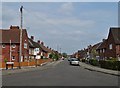
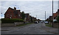
10
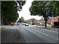
Mansfield Road (B6030)
Heading west through Clipstone.
Image: © JThomas
Taken: 7 Sep 2013
0.23 miles