IMAGES TAKEN NEAR TO
Buttercup Meadow, MANSFIELD, NG21 9FP
Introduction
This page details the photographs taken nearby to Buttercup Meadow, NG21 9FP by members of the Geograph project.
The Geograph project started in 2005 with the aim of publishing, organising and preserving representative images for every square kilometre of Great Britain, Ireland and the Isle of Man.

There are currently over 7.5m images from over14,400 individuals and you can help contribute to the project by visiting https://www.geograph.org.uk
Image Map
Images are licensed for reuse under creativecommons.org/licenses/by-sa/2.0
Notes
- Clicking on the map will re-center to the selected point.
- The higher the marker number, the further away the image location is from the centre of the postcode.
Image Listing (7 Images Found)
Images are licensed for reuse under creativecommons.org/licenses/by-sa/2.0
Image
Details
Distance
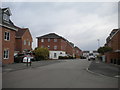
1
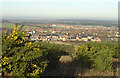
New Clipstone from the south
The view from the old colliery waste tip, now a Country Park. Despite the closure of the colliery there has been a considerable amount of new housing development.
Image: © Alan Murray-Rust
Taken: 23 Dec 2007
0.08 miles
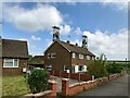
2

View towards Clipstone Colliery headstocks
Grade 2 listed buildings
Image: © Chris Morgan
Taken: 3 Oct 2017
0.17 miles
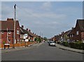
3
Houses on The Circle, Clipstone
With the colliery headstones "emerging" from the roofs.
Image: © David Lally
Taken: 7 May 2022
0.21 miles
5
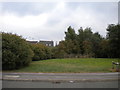
Hilcote Drive Open Space, Clipstone
Seen here pretty much in its entirety. In the distance, the headstocks at the former Clipstone Colliery can just be picked out.
Image: © Richard Vince
Taken: 15 Aug 2020
0.22 miles
6
Hilcote Drive, Clipstone
Seen from Ward Road.
Image: © Richard Vince
Taken: 15 Aug 2020
0.23 miles
7
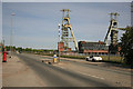
Only the headstock remains
Clipstone Mine has been cleared apart from the Pit headstock.
Image: © roger geach
Taken: 4 May 2011
0.25 miles