IMAGES TAKEN NEAR TO
Kings Clipstone, MANSFIELD, NG21 9BJ
Introduction
This page details the photographs taken nearby to NG21 9BJ by members of the Geograph project.
The Geograph project started in 2005 with the aim of publishing, organising and preserving representative images for every square kilometre of Great Britain, Ireland and the Isle of Man.

There are currently over 7.5m images from over14,400 individuals and you can help contribute to the project by visiting https://www.geograph.org.uk
Image Map
Images are licensed for reuse under creativecommons.org/licenses/by-sa/2.0
Notes
- Clicking on the map will re-center to the selected point.
- The higher the marker number, the further away the image location is from the centre of the postcode.
Image Listing (11 Images Found)
Images are licensed for reuse under creativecommons.org/licenses/by-sa/2.0
Image
Details
Distance
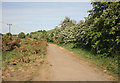
1
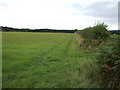
Mansfield Road (B6030)
Towards New Clipstone.
Image: © JThomas
Taken: 7 Sep 2013
0.11 miles
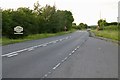
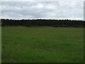
2
Shades of green
From NCN route 6 = There's too many metal gates round here!
Image: © David Lally
Taken: 18 Jun 2018
0.13 miles
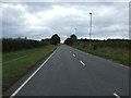
4
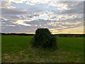
Hedge and a sunset sky
Field beside the B6030 between Kings Clipstone and Clipstone.
Image: © David Lally
Taken: 5 Jul 2014
0.14 miles
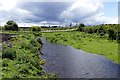
6
Improper dumping of manure?
Equestrian activity is popular in this area. But these unprotected piles of stable waste should surely not be dumped alongside a water course (the stream Vicar Water) in a 'Nitrate Vulnerable Zone'.
Image: © Tim Heaton
Taken: 19 May 2013
0.17 miles
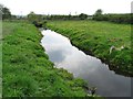
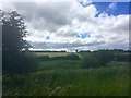
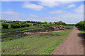
8
Vicar Water
Looking south west towards the headstocks of the former Clipstone Colliery Image
Image: © Graham Hogg
Taken: 2 Jun 2015
0.17 miles