IMAGES TAKEN NEAR TO
Baulker Lane, MANSFIELD, NG21 9BG
Introduction
This page details the photographs taken nearby to Baulker Lane, NG21 9BG by members of the Geograph project.
The Geograph project started in 2005 with the aim of publishing, organising and preserving representative images for every square kilometre of Great Britain, Ireland and the Isle of Man.

There are currently over 7.5m images from over14,400 individuals and you can help contribute to the project by visiting https://www.geograph.org.uk
Image Map
Images are licensed for reuse under creativecommons.org/licenses/by-sa/2.0
Notes
- Clicking on the map will re-center to the selected point.
- The higher the marker number, the further away the image location is from the centre of the postcode.
Image Listing (18 Images Found)
Images are licensed for reuse under creativecommons.org/licenses/by-sa/2.0
Image
Details
Distance
1
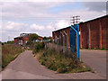
Industrial Buildings
Some industrial buildings in Clipstone.
Image: © James Hill
Taken: 29 Aug 2007
0.01 miles

3
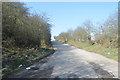
Old Road
Currently connecting a few industrial units and a refrigeration workshop.
Image: © Ashley Dace
Taken: 8 Mar 2011
0.10 miles
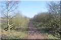
4

Cycle Route 6 on bridleway towards King John's Palace
Image: © Tim Heaton
Taken: 19 May 2013
0.14 miles
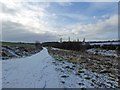
5

Route 6
NCN route 6 near Clipstone with some disgusting fly-tipped debris
Image: © Richard Croft
Taken: 25 Nov 2011
0.14 miles
6

Overgrown track, Sherwood Pines
Known locally as "Sandy Lane", because of the very sandy soil here, this path is well on the way to becoming completely overgrown with brambles and bracken. It borders the area where the Pines Park Archers club shoots, and is probably little used.
Image: © Lynne Kirton
Taken: 4 Nov 2006
0.15 miles
7
Bridleway to Old Clipstone
Bridleway on its way to Old Clipstone.
Image: © Ashley Dace
Taken: 8 Mar 2011
0.15 miles
8
NCN route 6 and in the distance a rare sighting of coal mine head gear
Image: © Steve Fareham
Taken: 3 Feb 2015
0.17 miles
9
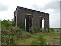
Remnant of The Coal Industry
This building was probably connected with the loading or hoisting of coal wagons taking coal or waste from nearby Clipstone Colliery. It is located by a former railway line that once served the colliery.
Image: © Neil Theasby
Taken: 30 Apr 2019
0.18 miles
10
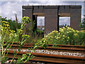
Old colliery structure
This appears to be what is left of some colliery building. Given the height of the structure, possibly something to load and/or unload rail stock. It is certainly visible on Google Earth
Image: © James Hill
Taken: 4 Jul 2009
0.18 miles