IMAGES TAKEN NEAR TO
Linnet Drive, MANSFIELD, NG21 0WL
Introduction
This page details the photographs taken nearby to Linnet Drive, NG21 0WL by members of the Geograph project.
The Geograph project started in 2005 with the aim of publishing, organising and preserving representative images for every square kilometre of Great Britain, Ireland and the Isle of Man.

There are currently over 7.5m images from over14,400 individuals and you can help contribute to the project by visiting https://www.geograph.org.uk
Image Map
Images are licensed for reuse under creativecommons.org/licenses/by-sa/2.0
Notes
- Clicking on the map will re-center to the selected point.
- The higher the marker number, the further away the image location is from the centre of the postcode.
Image Listing (10 Images Found)
Images are licensed for reuse under creativecommons.org/licenses/by-sa/2.0
Image
Details
Distance
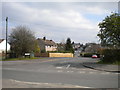
2
West end of Tudor Crescent, Rainworth
Off Preston Road.
Image: © Richard Vince
Taken: 6 Apr 2019
0.08 miles
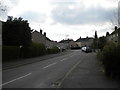
3

Preston Road, Rainworth
Near the southern edge of the village.
Image: © Richard Vince
Taken: 6 Apr 2019
0.10 miles
4
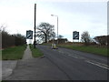
Leaving Rainworth
Southbound on the B6020 towards Blidworth.
Image: © JThomas
Taken: 17 Mar 2014
0.10 miles

6
West end of Preston Road, Rainworth
Seen from Warsop Lane.
Image: © Richard Vince
Taken: 6 Apr 2019
0.12 miles

9
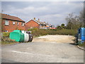
Recycling point off Warsop Lane, Rainworth
Featuring three colours of bottle bank, something I haven't seen for many years.
Image: © Richard Vince
Taken: 6 Apr 2019
0.20 miles
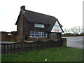
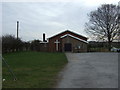
10

Staff and delivery entrance to Joseph Whitaker School, Rainworth
Off Warsop Lane.
Image: © Richard Vince
Taken: 6 Apr 2019
0.20 miles