IMAGES TAKEN NEAR TO
Elderberry Way, NG21 0UW
Introduction
This page details the photographs taken nearby to Elderberry Way, NG21 0UW by members of the Geograph project.
The Geograph project started in 2005 with the aim of publishing, organising and preserving representative images for every square kilometre of Great Britain, Ireland and the Isle of Man.

There are currently over 7.5m images from over14,400 individuals and you can help contribute to the project by visiting https://www.geograph.org.uk
Image Map
Images are licensed for reuse under creativecommons.org/licenses/by-sa/2.0
Notes
- Clicking on the map will re-center to the selected point.
- The higher the marker number, the further away the image location is from the centre of the postcode.
Image Listing (4 Images Found)
Images are licensed for reuse under creativecommons.org/licenses/by-sa/2.0
Image
Details
Distance
1
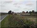
Three Thorn Hollow Farm
viewed north along Blidworth Lane
Image: © Tom Courtney
Taken: 9 Oct 2005
0.12 miles
2
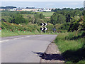
Particularly bad corner
This is a particularly nefarious corner on Three Thorn Hollow that I can personally vouch for! The road has now been widened which is a great help to motorists as it is a blind corner that crests a hill with a pond on one side and a marsh on the other. Many accidents have occurred here over the past but since the improvements were made, incidents appear to have decreased. The land owner must be relieved also as he no longer needs to keep repairing his hedges!
Image: © James Hill
Taken: 23 May 2007
0.18 miles
3
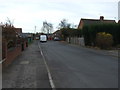
Helmsley Road
Heading south towards the B6020.
Image: © JThomas
Taken: 17 Mar 2014
0.22 miles
4
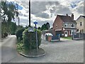
An erroneous NCN sign?
For NCN Route 6 without brackets. This implying that tis is on the route. However, Route 6 does not go along here and I don't think it ever did. With brackets it should be pointing in the other direction too!
Image: © David Lally
Taken: 31 Aug 2023
0.23 miles