IMAGES TAKEN NEAR TO
Park Avenue, MANSFIELD, NG21 0SN
Introduction
This page details the photographs taken nearby to Park Avenue, NG21 0SN by members of the Geograph project.
The Geograph project started in 2005 with the aim of publishing, organising and preserving representative images for every square kilometre of Great Britain, Ireland and the Isle of Man.

There are currently over 7.5m images from over14,400 individuals and you can help contribute to the project by visiting https://www.geograph.org.uk
Image Map
Images are licensed for reuse under creativecommons.org/licenses/by-sa/2.0
Notes
- Clicking on the map will re-center to the selected point.
- The higher the marker number, the further away the image location is from the centre of the postcode.
Image Listing (8 Images Found)
Images are licensed for reuse under creativecommons.org/licenses/by-sa/2.0
Image
Details
Distance
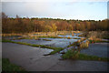
3
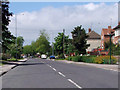
View of Dale Lane
Looking west down Dale Lane in Blidworth.
Image: © James Hill
Taken: 23 May 2007
0.17 miles
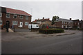
5

Blidworth village sign
On the eastern approach to the village on Dale Lane
Image: © Graham Hogg
Taken: 22 Feb 2016
0.21 miles
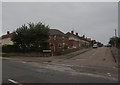
7

Bus Stop and Street Corner in Blidworth
Image: © Jonathan Clitheroe
Taken: 16 Sep 2023
0.22 miles
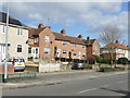
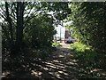
8
Site of Blidworth Colliery
Concrete area on the site of Blidworth Colliery
Image: © Richard Croft
Taken: 25 Nov 2011
0.24 miles