IMAGES TAKEN NEAR TO
Forest Road, MANSFIELD, NG21 0SJ
Introduction
This page details the photographs taken nearby to Forest Road, NG21 0SJ by members of the Geograph project.
The Geograph project started in 2005 with the aim of publishing, organising and preserving representative images for every square kilometre of Great Britain, Ireland and the Isle of Man.

There are currently over 7.5m images from over14,400 individuals and you can help contribute to the project by visiting https://www.geograph.org.uk
Image Map
Images are licensed for reuse under creativecommons.org/licenses/by-sa/2.0
Notes
- Clicking on the map will re-center to the selected point.
- The higher the marker number, the further away the image location is from the centre of the postcode.
Image Listing (6 Images Found)
Images are licensed for reuse under creativecommons.org/licenses/by-sa/2.0
Image
Details
Distance
1
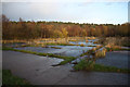
Site of Blidworth Colliery
Concrete area on the site of Blidworth Colliery
Image: © Richard Croft
Taken: 25 Nov 2011
0.11 miles
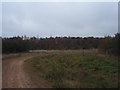
3
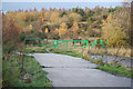
Route 6
NCN route 6 across the site of Blidworth Colliery
Image: © Richard Croft
Taken: 25 Nov 2011
0.16 miles
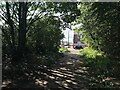
4
Path to Burma Road
A link from National Cycle Route 6 to the road network.
Image: © Jonathan Thacker
Taken: 5 Jan 2020
0.20 miles
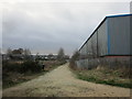
5
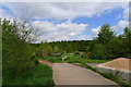
Entrance to Boundary Wood, Blidworth
Forestry Commission land with a variety of public footpaths and Cycle Route 6
Image: © Tim Heaton
Taken: 19 May 2013
0.21 miles
6
Boundary Wood
Boundary Wood, Blidworth, near Mansfield.
Image: © Ajay Tegala
Taken: 30 Oct 2008
0.22 miles