IMAGES TAKEN NEAR TO
Field Lane, MANSFIELD, NG21 0QQ
Introduction
This page details the photographs taken nearby to Field Lane, NG21 0QQ by members of the Geograph project.
The Geograph project started in 2005 with the aim of publishing, organising and preserving representative images for every square kilometre of Great Britain, Ireland and the Isle of Man.

There are currently over 7.5m images from over14,400 individuals and you can help contribute to the project by visiting https://www.geograph.org.uk
Image Map
Images are licensed for reuse under creativecommons.org/licenses/by-sa/2.0
Notes
- Clicking on the map will re-center to the selected point.
- The higher the marker number, the further away the image location is from the centre of the postcode.
Image Listing (39 Images Found)
Images are licensed for reuse under creativecommons.org/licenses/by-sa/2.0
Image
Details
Distance
1
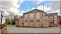
Blidworth, Sherwood Forest, Methodist church
Their website says "There has been a Church on the site since 1787 with a number of rebuilding and refurbishments taking place. The church was refurbished some 6 years ago with the pews being replaced with chairs."
It amalgamated with the Sherwood Forest Primitive Methodist chapel in Dale Road. It's now become a menswear store.
Image: © Chris Morgan
Taken: 22 Feb 2016
0.02 miles
2
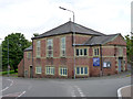
Blidworth Methodist Church
The present building dates from 1933, but there has been a chapel on the site since 1787.
Image: © Alan Murray-Rust
Taken: 1 Jun 2014
0.02 miles
3
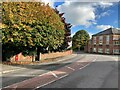
Main Street in Blidworth
The building on the right of picture is a Methodist Church.
Image: © Jonathan Clitheroe
Taken: 8 Oct 2022
0.03 miles
4
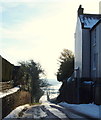
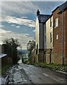
Towards Blidworth Bottoms, Notts.
Blidworth Bottoms is a hamlet to the south of Blidworth consisting of a public house, a few houses and several farms. This is Field Lane that descends to it from the highest part of Main Street, in the village of Blidworth.
Image: © David Hallam-Jones
Taken: 31 Dec 2014
0.03 miles
5
Main Street, Blidworth, Notts.
Situated at the junction of Main Street and Field Lane (the latter leading to Blidworth Bottoms) the Black Bull Public House and Bistro dates back to the C17th. In 1878 it became the property of Shipstones and this partnership continued until 1978 when Shipstone & Sons - brewers between 1852 and 1991 - were taken over by Greenalls of Warrington. It seems that several transfers of ownership followed until autumn 2012 when it came back into private ownership. This is 'almost' the highest point in the village although this road (the B6020) passes the Parish Church - which is situated at an even higher point - before it descends towards Ravenshead. Most of the village is located at lower levels, behind the photographer.
Image: © David Hallam-Jones
Taken: 31 Dec 2014
0.03 miles
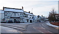
7
Join the dots
And you'll see that this used to be The White Lion public house which closed its doors in 2013.
Image: © Graham Hogg
Taken: 22 Feb 2016
0.04 miles
8
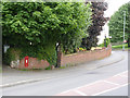
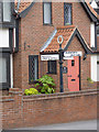
Blidworth Main Street
Showing the location of the postbox http://www.geograph.org.uk/photo/4015707 and fingerpost http://www.geograph.org.uk/photo/4015700
Image: © Alan Murray-Rust
Taken: 1 Jun 2014
0.04 miles
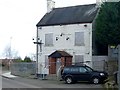
9
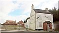
The White Lion, Blidworth
Sadly, more like a dying swan, but no longer white.
Image: © Chris Morgan
Taken: 22 Feb 2016
0.04 miles
10
Fingerpost at Main Street/Field Lane
The traditional fingerpost has survived despite being on a B-classified road. Notts C C traditional cast-iron with annulus finial.
Image: © Alan Murray-Rust
Taken: 1 Jun 2014
0.04 miles