IMAGES TAKEN NEAR TO
Warsop Lane, MANSFIELD, NG21 0PG
Introduction
This page details the photographs taken nearby to Warsop Lane, NG21 0PG by members of the Geograph project.
The Geograph project started in 2005 with the aim of publishing, organising and preserving representative images for every square kilometre of Great Britain, Ireland and the Isle of Man.

There are currently over 7.5m images from over14,400 individuals and you can help contribute to the project by visiting https://www.geograph.org.uk
Image Map
Images are licensed for reuse under creativecommons.org/licenses/by-sa/2.0
Notes
- Clicking on the map will re-center to the selected point.
- The higher the marker number, the further away the image location is from the centre of the postcode.
Image Listing (5 Images Found)
Images are licensed for reuse under creativecommons.org/licenses/by-sa/2.0
Image
Details
Distance
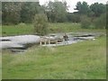
3
Tippings Wood pond
Nature reserve on the site of Blidworth colliery
Image: © Jim Thornton
Taken: Unknown
0.20 miles
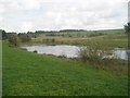
4
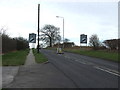
Leaving Rainworth
Southbound on the B6020 towards Blidworth.
Image: © JThomas
Taken: 17 Mar 2014
0.23 miles