IMAGES TAKEN NEAR TO
Haywood Oaks Lane, MANSFIELD, NG21 0PE
Introduction
This page details the photographs taken nearby to Haywood Oaks Lane, NG21 0PE by members of the Geograph project.
The Geograph project started in 2005 with the aim of publishing, organising and preserving representative images for every square kilometre of Great Britain, Ireland and the Isle of Man.

There are currently over 7.5m images from over14,400 individuals and you can help contribute to the project by visiting https://www.geograph.org.uk
Image Map
Images are licensed for reuse under creativecommons.org/licenses/by-sa/2.0
Notes
- Clicking on the map will re-center to the selected point.
- The higher the marker number, the further away the image location is from the centre of the postcode.
Image Listing (8 Images Found)
Images are licensed for reuse under creativecommons.org/licenses/by-sa/2.0
Image
Details
Distance
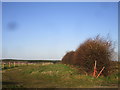
3
Truncated hedgerow, south of Haywood Oaks Lane
Access to both fields has a higher priority than joining up the hedgerows.
Image: © Christine Johnstone
Taken: 5 Jun 2013
0.22 miles
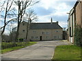
4
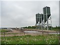
Storage tanks at the pig farm
On the north-east side of Haywood Oaks Lane.
Image: © Christine Johnstone
Taken: 5 Jun 2013
0.23 miles
5
Hedgerow and access to pony paddocks
Image: © Jonathan Thacker
Taken: 3 Jan 2020
0.24 miles
6
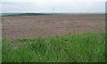
Large field north-west of Haywood Oaks Farm
On the south-west side of Haywood Oaks Lane.
Image: © Christine Johnstone
Taken: 5 Jun 2013
0.24 miles
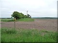
7
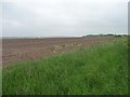
Uncultivated field margin
Mapped as a track, but the farm vehicles use the field itself, and not this strip between the lane hedge and the fence.
Image: © Christine Johnstone
Taken: 5 Jun 2013
0.25 miles
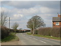
8
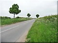
Haywood Oaks Lane
Heading over a small 125 metre summit, towards Blidworth.
Image: © Christine Johnstone
Taken: 5 Jun 2013
0.25 miles