IMAGES TAKEN NEAR TO
Rigg Lane, MANSFIELD, NG21 0NT
Introduction
This page details the photographs taken nearby to Rigg Lane, NG21 0NT by members of the Geograph project.
The Geograph project started in 2005 with the aim of publishing, organising and preserving representative images for every square kilometre of Great Britain, Ireland and the Isle of Man.

There are currently over 7.5m images from over14,400 individuals and you can help contribute to the project by visiting https://www.geograph.org.uk
Image Map
Images are licensed for reuse under creativecommons.org/licenses/by-sa/2.0
Notes
- Clicking on the map will re-center to the selected point.
- The higher the marker number, the further away the image location is from the centre of the postcode.
Image Listing (6 Images Found)
Images are licensed for reuse under creativecommons.org/licenses/by-sa/2.0
Image
Details
Distance
1
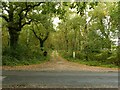
Woodland track
Private drive to Appleton Dale.
Image: © Alan Murray-Rust
Taken: 11 Oct 2020
0.14 miles
2
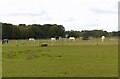
The modern face of farming
Grazing land converted to horse paddocks.
Image: © Alan Murray-Rust
Taken: 11 Oct 2020
0.14 miles
3
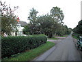
Sherwood House on Rigg Lane
Peeping through the gates, I spied a lot of fairground rides. Do some show people winter here ???
Image: © Tom Courtney
Taken: 25 Sep 2005
0.16 miles
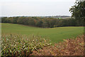
4
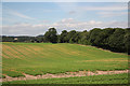
Appleton Dale
Blidworth woodland seen from Rigg Lane
Image: © Richard Croft
Taken: 9 Jul 2010
0.17 miles
5
Appleton Dale
Woodland which appears to have been originally established as a game covert.
Image: © Alan Murray-Rust
Taken: 23 Oct 2011
0.20 miles
6
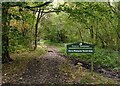
Horse riding by permit only
Notice on the edge of Blidworth Woods. The ride ahead is one of those designated as a horse trail.
Image: © Alan Murray-Rust
Taken: 11 Oct 2020
0.24 miles