IMAGES TAKEN NEAR TO
Cross Lane, MANSFIELD, NG21 0LY
Introduction
This page details the photographs taken nearby to Cross Lane, NG21 0LY by members of the Geograph project.
The Geograph project started in 2005 with the aim of publishing, organising and preserving representative images for every square kilometre of Great Britain, Ireland and the Isle of Man.

There are currently over 7.5m images from over14,400 individuals and you can help contribute to the project by visiting https://www.geograph.org.uk
Image Map
Images are licensed for reuse under creativecommons.org/licenses/by-sa/2.0
Notes
- Clicking on the map will re-center to the selected point.
- The higher the marker number, the further away the image location is from the centre of the postcode.
Image Listing (26 Images Found)
Images are licensed for reuse under creativecommons.org/licenses/by-sa/2.0
Image
Details
Distance
1
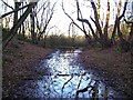
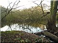
Cave Pond
Hard to believe that this unprepossessing morass is shown on the map as a pond.
There is no sign of a cave . . .
Image: © Antony Dixon
Taken: 27 Dec 2011
0.05 miles
2
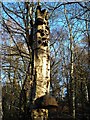
Old birch stump near Cave Pond
. . . complete with woodpecker holes and heavy-duty bracket fungus.
Image: © Antony Dixon
Taken: 27 Dec 2011
0.05 miles
3
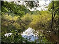
Cave Pond at Rainworth Water
Heavily overgrown historic pond which is probably better viewed in the winter months.
Image: © Jonathan Clitheroe
Taken: 8 Oct 2022
0.06 miles
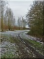
4
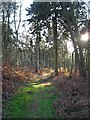
Forest path near Cave Pond
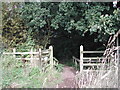
Not an official path marked on the map, but obviously well used.
Image: © Antony Dixon
Taken: 27 Dec 2011
0.07 miles
6

Cave Pond, Fountain Dale, Ravenhead, Notts.
Part of Cave Pond ("Private Property) viewed from just off a public footpath that continues on towards Blidworth Lane. (Walkers using the Robin Hood Trail will have turned off this particular path five minutes earlier, in the direction of Providence Farm). Tradition has it that when the curtal friar, Friar Tuck, was evicted from his cave after a seven year period of 'defending' a nearby chapel that containing a holy shrine, the well that supplied this pond dried up for the same length of time as the result of a curse placed on it by the canons of Newstead Abbey and that ever since then, the well has only produced water every seventh year.
Image: © David Hallam-Jones
Taken: 10 Nov 2013
0.09 miles
7
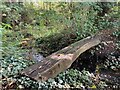
Log Bridge at Cave Pond
Rudimentary wooden bridge spanning Rainworth Water as it drains from Cave Pond.
Image: © Jonathan Clitheroe
Taken: 8 Oct 2022
0.10 miles
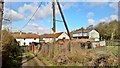
8
Path to Rainworth - north of Providence Farm
Image: © Neil Theasby
Taken: 30 Dec 2020
0.11 miles
10
Bridleway
going northeast from Providence Farm
Image: © Tom Courtney
Taken: 25 Sep 2005
0.11 miles