IMAGES TAKEN NEAR TO
Beverley Close, MANSFIELD, NG21 0LW
Introduction
This page details the photographs taken nearby to Beverley Close, NG21 0LW by members of the Geograph project.
The Geograph project started in 2005 with the aim of publishing, organising and preserving representative images for every square kilometre of Great Britain, Ireland and the Isle of Man.

There are currently over 7.5m images from over14,400 individuals and you can help contribute to the project by visiting https://www.geograph.org.uk
Image Map
Images are licensed for reuse under creativecommons.org/licenses/by-sa/2.0
Notes
- Clicking on the map will re-center to the selected point.
- The higher the marker number, the further away the image location is from the centre of the postcode.
Image Listing (15 Images Found)
Images are licensed for reuse under creativecommons.org/licenses/by-sa/2.0
Image
Details
Distance
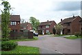
1
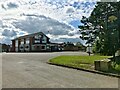
The Sherwood
A typical mid-20th Century estate pub on the outskirts of Rainworth. Built in the late '60s or early '70s I would guess.
Image: © David Lally
Taken: 31 Aug 2023
0.18 miles

3
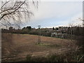
The fringe of Rainworth seen from Cycle Route 6
Cycle Route 6 runs along the course of a former mineral railway.
Image: © Jonathan Thacker
Taken: 5 Jan 2020
0.22 miles
4
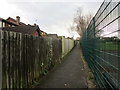
Footpath behind Briar Close, Rainworth
Image: © Jonathan Thacker
Taken: 12 Jan 2020
0.22 miles
5
Path up to Cycle Route 6
The path zig-zags up from Mansfield Road to the course of a onetime mineral railway which now forms part of National Cycle Route 6.
Image: © Jonathan Thacker
Taken: 5 Jan 2020
0.24 miles
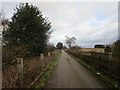
7

Path down from Cycle Route 6
Looking towards Boundary Wood the reclaimed slag heap of the former Blidworth Colliery.
Image: © Jonathan Thacker
Taken: 5 Jan 2020
0.24 miles
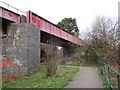
8

Cycle Route 6 approaching a bridge over Mansfield Road, Rainworth
Following a former colliery railway line
Image: © Tim Heaton
Taken: 19 May 2013
0.24 miles
9

Mansfield Road bridge
NCN route 6 on a former railway bridge over Mansfield Road
Image: © Richard Croft
Taken: 25 Nov 2011
0.24 miles
10
National Cycle Route 6
Looking towards the bridge crossing Mansfield Road.
Image: © Jonathan Thacker
Taken: 5 Jan 2020
0.24 miles