IMAGES TAKEN NEAR TO
Cambridge Close, MANSFIELD, NG21 0AY
Introduction
This page details the photographs taken nearby to Cambridge Close, NG21 0AY by members of the Geograph project.
The Geograph project started in 2005 with the aim of publishing, organising and preserving representative images for every square kilometre of Great Britain, Ireland and the Isle of Man.

There are currently over 7.5m images from over14,400 individuals and you can help contribute to the project by visiting https://www.geograph.org.uk
Image Map
Images are licensed for reuse under creativecommons.org/licenses/by-sa/2.0
Notes
- Clicking on the map will re-center to the selected point.
- The higher the marker number, the further away the image location is from the centre of the postcode.
Image Listing (5 Images Found)
Images are licensed for reuse under creativecommons.org/licenses/by-sa/2.0
Image
Details
Distance
2
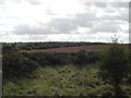
Gorse and farmland
viewed SW from the Mansfield Road at Rainworth
Image: © Tom Courtney
Taken: 25 Sep 2005
0.13 miles
3
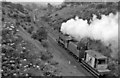
Blidworth & Rainworth Station (remains)
View NW, towards Mansfield. Station (remains) are in left distance, ahead of the Engine (a Stanier Class 8F 2-8-0) and brake. This is the ex-Midland Mansfield - Rolleston Junction line in its last throes, having lost its passenger service on 12/8/29 and closing completely on 1/2/65.
Image: © Ben Brooksbank
Taken: 12 Jul 1963
0.18 miles

5
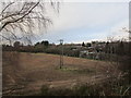
The fringe of Rainworth seen from Cycle Route 6
Cycle Route 6 runs along the course of a former mineral railway.
Image: © Jonathan Thacker
Taken: 5 Jan 2020
0.25 miles