IMAGES TAKEN NEAR TO
Scarcliffe Lanes, MANSFIELD, NG20 9RQ
Introduction
This page details the photographs taken nearby to Scarcliffe Lanes, NG20 9RQ by members of the Geograph project.
The Geograph project started in 2005 with the aim of publishing, organising and preserving representative images for every square kilometre of Great Britain, Ireland and the Isle of Man.

There are currently over 7.5m images from over14,400 individuals and you can help contribute to the project by visiting https://www.geograph.org.uk
Image Map
Images are licensed for reuse under creativecommons.org/licenses/by-sa/2.0
Notes
- Clicking on the map will re-center to the selected point.
- The higher the marker number, the further away the image location is from the centre of the postcode.
Image Listing (37 Images Found)
Images are licensed for reuse under creativecommons.org/licenses/by-sa/2.0
Image
Details
Distance
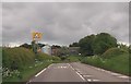
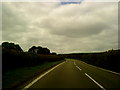
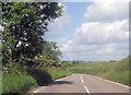
2
Upper Langwith - Scarcliffe Lane (A632)
Image: © Alan Heardman
Taken: 15 Nov 2008
0.06 miles
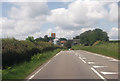
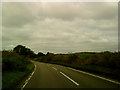
8
Autumnal Scene in Upper Langwith
Road leading eastwards out of the village - decorated here with autumnal colour.
Image: © Jonathan Clitheroe
Taken: 28 Oct 2011
0.13 miles
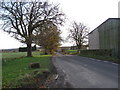
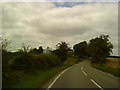
10
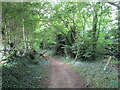
Footpath to Rotherham Road
Passes through Dean's Plantation and Langwith Wood.
Image: © Jonathan Thacker
Taken: 25 Jul 2021
0.14 miles