IMAGES TAKEN NEAR TO
Netherfield Lane, MANSFIELD, NG20 9RA
Introduction
This page details the photographs taken nearby to Netherfield Lane, NG20 9RA by members of the Geograph project.
The Geograph project started in 2005 with the aim of publishing, organising and preserving representative images for every square kilometre of Great Britain, Ireland and the Isle of Man.

There are currently over 7.5m images from over14,400 individuals and you can help contribute to the project by visiting https://www.geograph.org.uk
Image Map
Images are licensed for reuse under creativecommons.org/licenses/by-sa/2.0
Notes
- Clicking on the map will re-center to the selected point.
- The higher the marker number, the further away the image location is from the centre of the postcode.
Image Listing (16 Images Found)
Images are licensed for reuse under creativecommons.org/licenses/by-sa/2.0
Image
Details
Distance
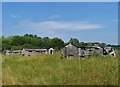
1
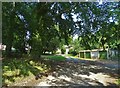
At Gleadthorpe Cottages
A small housing development associated with the adjacent research farm - now disused.
Image: © Neil Theasby
Taken: 11 Aug 2020
0.03 miles
2
Entrance to ADAS at Gleadthorpe
ADAS is the UK’s largest independent provider of environmental consultancy, rural development services and policy advice.
Image: © Steve Fareham
Taken: 13 Mar 2009
0.06 miles
3

Old Research Farm
As far as I am aware, this was used for reaserch into livestock, probably chickens and - I think - was part of ADAS Gleadthorpe. http://www.adas.co.uk/where_we_are/index.html
The site, although fenced off, seems deserted but (once again) I think it was recently sold so it may be undergoing a change soon.
Image: © James Hill
Taken: 22 Aug 2009
0.10 miles
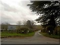
4
The Road To Budby
The road going past Gleadthorpe Grange (right) from Meden Vale to Budby Crossroads (i think this is an unclassified road)
Image: © David Simpson
Taken: 18 Jul 2008
0.13 miles
6
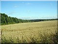
Field (Gleadthorpe)
A field on the edge of Gleadthorpe Breck plantation looking SW, site of a Roman temporary fort (ref; www.Pastscape.com )
Image: © David Simpson
Taken: 28 Aug 2008
0.15 miles
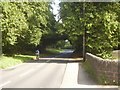
7
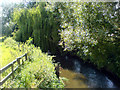
River Meden
The River Meden as it flows under Robin Hood Way.
Image: © James Hill
Taken: 10 Aug 2007
0.17 miles
8
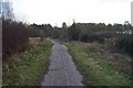
Hanger Hill Drive
Bridleway just south of Netherfield Lane showing where it crosses the River Meden.
Image: © Ann B
Taken: 18 Feb 2006
0.18 miles
9
Abandoned chicken farm south of The River Meden
At Gleadthorpe Grange
Image: © Neil Theasby
Taken: 11 Aug 2020
0.21 miles
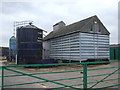
10
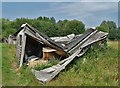
Ruin of a chicken shack at Gleadthorpe Grange
Image: © Neil Theasby
Taken: 11 Aug 2020
0.21 miles