IMAGES TAKEN NEAR TO
Cuckney, MANSFIELD, NG20 9NS
Introduction
This page details the photographs taken nearby to NG20 9NS by members of the Geograph project.
The Geograph project started in 2005 with the aim of publishing, organising and preserving representative images for every square kilometre of Great Britain, Ireland and the Isle of Man.

There are currently over 7.5m images from over14,400 individuals and you can help contribute to the project by visiting https://www.geograph.org.uk
Image Map
Images are licensed for reuse under creativecommons.org/licenses/by-sa/2.0
Notes
- Clicking on the map will re-center to the selected point.
- The higher the marker number, the further away the image location is from the centre of the postcode.
Image Listing (14 Images Found)
Images are licensed for reuse under creativecommons.org/licenses/by-sa/2.0
Image
Details
Distance
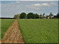
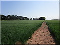
5
Bean field and Hilltop House
The footpath has not been maintained but a route can be found using tractor tracks.
Image: © Jonathan Thacker
Taken: 26 May 2018
0.05 miles
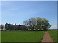
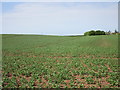
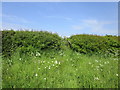
6
Field boundary of keck
Keck = cow parsley.
Hilltop Remise in the background.
Image: © Jonathan Thacker
Taken: 26 May 2018
0.12 miles
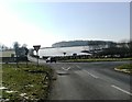
7
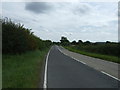
A616 towards New Ollerton
Heading south east.
Image: © JThomas
Taken: 28 Aug 2014
0.19 miles
8
Steep rise to the road
A few steps are needed for this path to reach the road.
Image: © Jonathan Thacker
Taken: 26 May 2018
0.20 miles
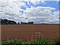
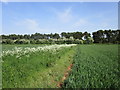
9
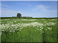
Overgrown path
A late spring has resulted in rapid growth of both grass and keck (cow parsley).
Image: © Jonathan Thacker
Taken: 26 May 2018
0.21 miles