IMAGES TAKEN NEAR TO
Cuckney Road, MANSFIELD, NG20 9JQ
Introduction
This page details the photographs taken nearby to Cuckney Road, NG20 9JQ by members of the Geograph project.
The Geograph project started in 2005 with the aim of publishing, organising and preserving representative images for every square kilometre of Great Britain, Ireland and the Isle of Man.

There are currently over 7.5m images from over14,400 individuals and you can help contribute to the project by visiting https://www.geograph.org.uk
Image Map
Images are licensed for reuse under creativecommons.org/licenses/by-sa/2.0
Notes
- Clicking on the map will re-center to the selected point.
- The higher the marker number, the further away the image location is from the centre of the postcode.
Image Listing (12 Images Found)
Images are licensed for reuse under creativecommons.org/licenses/by-sa/2.0
Image
Details
Distance
1
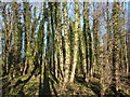
Beech trees, northwest corner of Cuckney Hay Wood
A stand of tall slender beeches, relatively young, most entwined with ivy.
Image: © Andrew Hill
Taken: 8 Jan 2011
0.09 miles
2
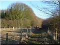
Path towards Cuckney Hay Wood
The path crosses a private track and continues by the line of trees.
Image: © Andrew Hill
Taken: 8 Jan 2011
0.11 miles
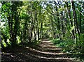
4
Footpath west through Cuckney Hay Wood
A woodland footpath, mainly beech trees in this vicinity.
Image: © Andrew Hill
Taken: 8 Jan 2011
0.13 miles
5
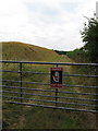
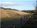
Quarry near Cuckney Hay Wood
This huge mound of soil now marks the boundary of the Limestone Quarry which was expanded about 10 years ago. The footpath that continues southwest through the next field and into the next square is now flanked by fences and hedgerow, along with numerous signs to remind us it is dangerous.
Image: © Sally Holmes
Taken: 29 Jul 2006
0.14 miles
6
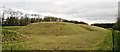
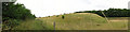
Curious landscaping of old quarry spoil at Nether Langwith
Lafarge stopped working the quarry in 2007, although these earthworks look unfinished - maybe a challenge for archaeologists in centuries to come!
Image: © Chris Morgan
Taken: 17 Jan 2014
0.16 miles
7
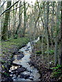
Small woodland stream by the A632
The stream is shown on the 1:25,000 map.
Image: © Andrew Hill
Taken: 8 Jan 2011
0.17 miles
8
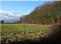
Field and woodland edge
Seen from a very overgrown footpath from Cuckney Hay Wood (when using it in Jan 2011).
Image: © Andrew Hill
Taken: 8 Jan 2011
0.18 miles
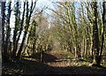
9
Path by quarry workings
When it leaves the woodland edge (when heading east) the path is then bounded by grass covered mounds of quarry workings, still with high hedges on the right and no distant views.
Image: © Andrew Hill
Taken: 8 Jan 2011
0.22 miles
10
Quarry spoil alongside footpath
This huge mound of soil was placed here when the nearby Limestone Quarry was expanded a few years ago. The footpath is now flanked by fences and hedgerow, along with numerous signs to remind us it is dangerous to play on(!).
Image: © Sally Holmes
Taken: 29 Jul 2006
0.23 miles