IMAGES TAKEN NEAR TO
Cockshut Lane, MANSFIELD, NG20 9JB
Introduction
This page details the photographs taken nearby to Cockshut Lane, NG20 9JB by members of the Geograph project.
The Geograph project started in 2005 with the aim of publishing, organising and preserving representative images for every square kilometre of Great Britain, Ireland and the Isle of Man.

There are currently over 7.5m images from over14,400 individuals and you can help contribute to the project by visiting https://www.geograph.org.uk
Image Map
Images are licensed for reuse under creativecommons.org/licenses/by-sa/2.0
Notes
- Clicking on the map will re-center to the selected point.
- The higher the marker number, the further away the image location is from the centre of the postcode.
Image Listing (20 Images Found)
Images are licensed for reuse under creativecommons.org/licenses/by-sa/2.0
Image
Details
Distance
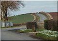
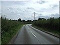
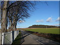
2
Lane towards Whaley Thorns
The road from the north, from the direction of Creswell and the A616.
Image: © Andrew Hill
Taken: 28 Feb 2012
0.03 miles
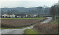
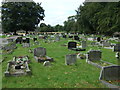
4
Lane north of Whaley Thorns
The lane passes the cemetery on the left. There was a good display of snowdrops in the verge.
Image: © Andrew Hill
Taken: 28 Feb 2012
0.04 miles
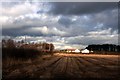
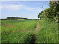
8
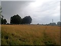
Footpath passing Whaley Thorns Cemetery
A shower was blowing over these fields on an otherwise warm August afternoon.
Image: © Jonathan Clitheroe
Taken: 2 Aug 2014
0.11 miles
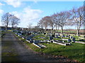
9
Road View - Leaving Whaley Thorns Cemetery
Image: © Alan Heardman
Taken: 30 Jan 2008
0.11 miles
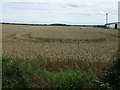
10
Footpath to the A616
Graves Wood in the distance.
Image: © Jonathan Thacker
Taken: 26 May 2018
0.12 miles