IMAGES TAKEN NEAR TO
Fairfield Close, MANSFIELD, NG20 9EP
Introduction
This page details the photographs taken nearby to Fairfield Close, NG20 9EP by members of the Geograph project.
The Geograph project started in 2005 with the aim of publishing, organising and preserving representative images for every square kilometre of Great Britain, Ireland and the Isle of Man.

There are currently over 7.5m images from over14,400 individuals and you can help contribute to the project by visiting https://www.geograph.org.uk
Image Map
Images are licensed for reuse under creativecommons.org/licenses/by-sa/2.0
Notes
- Clicking on the map will re-center to the selected point.
- The higher the marker number, the further away the image location is from the centre of the postcode.
Image Listing (42 Images Found)
Images are licensed for reuse under creativecommons.org/licenses/by-sa/2.0
Image
Details
Distance
1
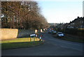
Lime Avenue
Looking down the road towards the main road
Image: © roger geach
Taken: 19 Feb 2012
0.04 miles
3
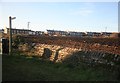
Over the Wall
A row of houses in the distance mark the road out of the village actros the field.
Image: © roger geach
Taken: 19 Feb 2012
0.09 miles
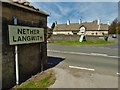
4
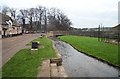
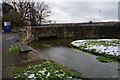
Stream at Nether Langwith
The stream which flows in front of the Jug and Glass Public House.
Image: © Ann B
Taken: 2 Jan 2006
0.10 miles
5
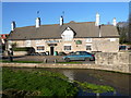
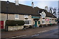
Nether Langwith - Jug & Glass Public House and Stream
Image: © Alan Heardman
Taken: 30 Jan 2008
0.10 miles
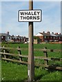
7
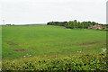
Emerging crop at Whaley Thorns
Looking east from Portland Road into Nottinghamshire from the boundary with Derbyshire.
Image: © Bill Boaden
Taken: 8 May 2022
0.11 miles
8
View to "The Jug and Glass Inn", Nether Langwith
Image: © Neil Theasby
Taken: 5 May 2016
0.11 miles