IMAGES TAKEN NEAR TO
Hartington Street, MANSFIELD, NG20 9DT
Introduction
This page details the photographs taken nearby to Hartington Street, NG20 9DT by members of the Geograph project.
The Geograph project started in 2005 with the aim of publishing, organising and preserving representative images for every square kilometre of Great Britain, Ireland and the Isle of Man.

There are currently over 7.5m images from over14,400 individuals and you can help contribute to the project by visiting https://www.geograph.org.uk
Image Map
Images are licensed for reuse under creativecommons.org/licenses/by-sa/2.0
Notes
- Clicking on the map will re-center to the selected point.
- The higher the marker number, the further away the image location is from the centre of the postcode.
Image Listing (13 Images Found)
Images are licensed for reuse under creativecommons.org/licenses/by-sa/2.0
Image
Details
Distance
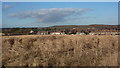
1

It's looking black over Bill's mother's
A heavy shower is about to replace some winter sunshine over houses in Langwith. We made it back to the car with minutes to spare before the deluge.
Image: © Graham Hogg
Taken: 17 Jan 2014
0.12 miles
2
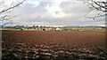
Across the field to Langwith
The soil a rich reddish brown, quite recently ploughed.
Image: © Chris Morgan
Taken: 17 Jan 2014
0.16 miles
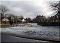
6
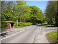
A632 entering Langwith
At the junction with Dale Close, opposite which is a small but well built bus shelter.
Image: © Richard Vince
Taken: 5 May 2018
0.21 miles
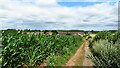
7
View towards Langwith from the south
Looking across open fields towards the village. The large field in the foreground has a crop of a tall member of the grass family seen quite a bit around these parts.
Image: © Andrew Hill
Taken: 8 Jan 2011
0.22 miles
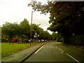
9
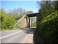
Footbridge across the A632 west of Langwith
A new footbridge deck has been placed on the abutments of the railway bridge that once carried the Beighton branch of the Lancashire, Derbyshire and East Coast Railway.
Image: © Richard Vince
Taken: 5 May 2018
0.23 miles
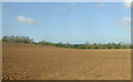
10
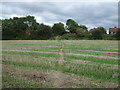
Footpath over stubble field
Heading east from the A632 towards Langwith.
Image: © JThomas
Taken: 28 Aug 2014
0.23 miles