IMAGES TAKEN NEAR TO
The Woodlands, MANSFIELD, NG20 9BX
Introduction
This page details the photographs taken nearby to The Woodlands, NG20 9BX by members of the Geograph project.
The Geograph project started in 2005 with the aim of publishing, organising and preserving representative images for every square kilometre of Great Britain, Ireland and the Isle of Man.

There are currently over 7.5m images from over14,400 individuals and you can help contribute to the project by visiting https://www.geograph.org.uk
Image Map
Images are licensed for reuse under creativecommons.org/licenses/by-sa/2.0
Notes
- Clicking on the map will re-center to the selected point.
- The higher the marker number, the further away the image location is from the centre of the postcode.
Image Listing (38 Images Found)
Images are licensed for reuse under creativecommons.org/licenses/by-sa/2.0
Image
Details
Distance
3
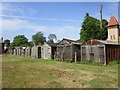
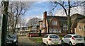
Wooden garages, Whaley Thorns
An uncommon sight nowadays.
Image: © Jonathan Thacker
Taken: 26 May 2018
0.10 miles
4
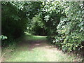
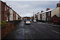
Path on disused railway, Whaley Thorns
Looking north.
Image: © JThomas
Taken: 28 Aug 2014
0.11 miles
5
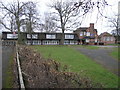
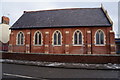
Whaley Thorns Primary School
Whaley Thorns Primary School, unusually quiet since it is half term week.
Image: © Michael Patterson
Taken: 21 Feb 2006
0.11 miles
6
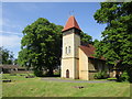
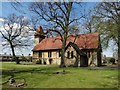
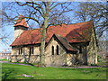
St. Luke's church, Whaley Thorns
Built 1878-9. Architect: J.B. Mitchell-Withers.
Image: © Jonathan Thacker
Taken: 26 May 2018
0.12 miles
8
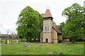
St Luke's Church, Whaley Thorns
A Victorian church now within the East Scarcliffe Team Ministry.
Image: © Bill Boaden
Taken: 8 May 2022
0.12 miles