IMAGES TAKEN NEAR TO
Carter Lane, MANSFIELD, NG20 8XA
Introduction
This page details the photographs taken nearby to Carter Lane, NG20 8XA by members of the Geograph project.
The Geograph project started in 2005 with the aim of publishing, organising and preserving representative images for every square kilometre of Great Britain, Ireland and the Isle of Man.

There are currently over 7.5m images from over14,400 individuals and you can help contribute to the project by visiting https://www.geograph.org.uk
Image Map
Images are licensed for reuse under creativecommons.org/licenses/by-sa/2.0
Notes
- Clicking on the map will re-center to the selected point.
- The higher the marker number, the further away the image location is from the centre of the postcode.
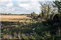
Image Listing (3 Images Found)
Images are licensed for reuse under creativecommons.org/licenses/by-sa/2.0
Image
Details
Distance
1
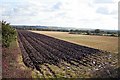
Ploughing has commenced
Perhaps it's too wet to plough today after the weekend's rain.
Image: © roger geach
Taken: 27 Oct 2008
0.11 miles
3
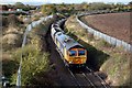
Coal empties for Thoresby Mine
An empty set of wagons heads towards Thoresby mine. On the left are the wagon works just out of sight.
Image: © roger geach
Taken: 27 Oct 2008
0.17 miles