IMAGES TAKEN NEAR TO
Roseland Lane, MANSFIELD, NG20 8EH
Introduction
This page details the photographs taken nearby to Roseland Lane, NG20 8EH by members of the Geograph project.
The Geograph project started in 2005 with the aim of publishing, organising and preserving representative images for every square kilometre of Great Britain, Ireland and the Isle of Man.

There are currently over 7.5m images from over14,400 individuals and you can help contribute to the project by visiting https://www.geograph.org.uk
Image Map
Images are licensed for reuse under creativecommons.org/licenses/by-sa/2.0
Notes
- Clicking on the map will re-center to the selected point.
- The higher the marker number, the further away the image location is from the centre of the postcode.
Image Listing (3 Images Found)
Images are licensed for reuse under creativecommons.org/licenses/by-sa/2.0
Image
Details
Distance
1
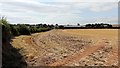
Looking toward Roseland Farm
The photograph is looking across a recently cropped field toward Roseland Farm. The hedgerow running from the near left toward the farm is the boundary between the field and Roseland Lane.
Image: © Alan Walker
Taken: 2 Aug 2018
0.03 miles
2
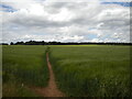
Public footpath west of Shirebrook (2)
Across a field towards Langwith Wood.
Image: © Richard Vince
Taken: 25 Jun 2022
0.21 miles
3
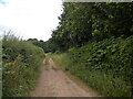
Public footpath west of Shirebrook (1)
Heading in the general direction of Scarcliffe.
Image: © Richard Vince
Taken: 25 Jun 2022
0.22 miles