IMAGES TAKEN NEAR TO
Laurel Avenue, MANSFIELD, NG20 0TE
Introduction
This page details the photographs taken nearby to Laurel Avenue, NG20 0TE by members of the Geograph project.
The Geograph project started in 2005 with the aim of publishing, organising and preserving representative images for every square kilometre of Great Britain, Ireland and the Isle of Man.

There are currently over 7.5m images from over14,400 individuals and you can help contribute to the project by visiting https://www.geograph.org.uk
Image Map
Images are licensed for reuse under creativecommons.org/licenses/by-sa/2.0
Notes
- Clicking on the map will re-center to the selected point.
- The higher the marker number, the further away the image location is from the centre of the postcode.
Image Listing (13 Images Found)
Images are licensed for reuse under creativecommons.org/licenses/by-sa/2.0
Image
Details
Distance
1
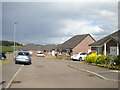
Vermont Close, Church Warsop
A recent small development of bungalows off the north end of Birch Street.
Image: © Richard Vince
Taken: 25 Jun 2022
0.07 miles
2

Birch Lane, Church Warsop, Notts.
A new housing development at the cul-de-sac end of Birch Lane, with views
towards Cuckney.
Image: © David Hallam-Jones
Taken: 28 Jan 2016
0.07 miles
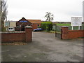
3
Access road to Church Vale Primary School, Church Warsop
Off Laurel Avenue.
Image: © Richard Vince
Taken: 25 Jun 2022
0.08 miles
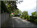
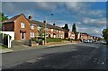
4
West end of Laurel Avenue, Church Warsop
Seen from its junction with Birch Street.
Image: © Richard Vince
Taken: 25 Jun 2022
0.08 miles
5
Church Warsop - Approaching Road Junction
Image: © Alan Heardman
Taken: 9 Nov 2008
0.15 miles
6
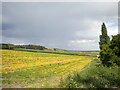
Field north of Church Warsop
Presided over by some distinctly smudgy looking clouds.
Image: © Richard Vince
Taken: 25 Jun 2022
0.16 miles
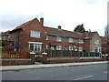
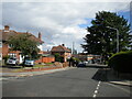
8
Church Warsop - Bethel Full Gospel Church
Image: © Alan Heardman
Taken: 9 Nov 2008
0.20 miles
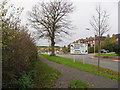
10
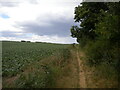
Field edge footpath north east of Church Warsop
Skirting the edge of the estate. The ends of gardens of houses on Lime Crescent are just the other side of the vegetation on the right.
Image: © Richard Vince
Taken: 25 Jun 2022
0.21 miles