IMAGES TAKEN NEAR TO
Moorfield Place, MANSFIELD, NG20 0QT
Introduction
This page details the photographs taken nearby to Moorfield Place, NG20 0QT by members of the Geograph project.
The Geograph project started in 2005 with the aim of publishing, organising and preserving representative images for every square kilometre of Great Britain, Ireland and the Isle of Man.

There are currently over 7.5m images from over14,400 individuals and you can help contribute to the project by visiting https://www.geograph.org.uk
Image Map
Images are licensed for reuse under creativecommons.org/licenses/by-sa/2.0
Notes
- Clicking on the map will re-center to the selected point.
- The higher the marker number, the further away the image location is from the centre of the postcode.
Image Listing (13 Images Found)
Images are licensed for reuse under creativecommons.org/licenses/by-sa/2.0
Image
Details
Distance
1
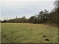
Grassland and woodland by the River Meden
Image: © Jonathan Thacker
Taken: 28 Jan 2022
0.15 miles
2
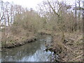
The River Meden near Church Warsop
Image: © Jonathan Thacker
Taken: 28 Jan 2022
0.16 miles
3
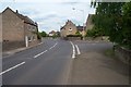
Manor Road, Old Church Warsop
Buildings on Manor Road, Old Church Warsop looking towards junction with Coggins Lane/Eastlands Lane.
Image: © Ann B
Taken: 29 May 2005
0.17 miles
4
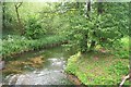
River Meden, Warsop
River Meden taken from Manor Road, Old Church Warsop, near junction with Burns Lane.
Image: © Ann B
Taken: 29 May 2005
0.17 miles
5
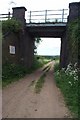
Railway Bridge, off Sandy Lane, Warsop
Railway bridge crossing bridleway looking down towards Burns Lane.
Image: © Ann B
Taken: 29 May 2005
0.17 miles
6
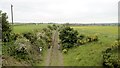
Welbeck Colliery branch line
The colliery closed in 2010 and nature is already reclaiming the trackbed.
Image: © Chris Morgan
Taken: 31 May 2016
0.19 miles
7
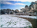
Footpath close to the River Meden
The land was cleared and grassed and the footpath created when the nearby small housing estate of Barn Owl Close was built.
Image: © Andy Stephenson
Taken: 17 Jan 2013
0.19 miles
8
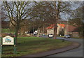
Church Road, Church Warsop, Notts.
The boundary with Market Warsop is two minutes walk away behind the photographer and traffic on the A60 is seen here entering and leaving Church Warsop. The parish church is visible behind the trees, with the C18th Grade II-listed water mill, Warsop Mill, on the right topped with bright orange tiles. The River Meden and the mill pond, plus a public car park serving The Carrs nature reserve, are situated on the left.
Image: © David Hallam-Jones
Taken: 23 Jan 2016
0.22 miles
9
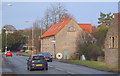
Church Road, Church Warsop, Notts.
The converted C18th Grade II-listed water mill, Warsop Mill, plus a glimpse of the parish church through the trees on the right.
Image: © David Hallam-Jones
Taken: 23 Jan 2016
0.22 miles
10

Church Road, Church Warsop, Notts.
Looking past the converted C18th Grade II-listed water mill, Warsop Mill towards the parish church. At the foot of the sloping graveyard and behind the war memorial is a public car park for the use of visitors to The Carrs, a local nature reserve, through which the River Meden passes.
Image: © David Hallam-Jones
Taken: 23 Jan 2016
0.23 miles