IMAGES TAKEN NEAR TO
George Street, MANSFIELD, NG20 0QA
Introduction
This page details the photographs taken nearby to George Street, NG20 0QA by members of the Geograph project.
The Geograph project started in 2005 with the aim of publishing, organising and preserving representative images for every square kilometre of Great Britain, Ireland and the Isle of Man.

There are currently over 7.5m images from over14,400 individuals and you can help contribute to the project by visiting https://www.geograph.org.uk
Image Map
Images are licensed for reuse under creativecommons.org/licenses/by-sa/2.0
Notes
- Clicking on the map will re-center to the selected point.
- The higher the marker number, the further away the image location is from the centre of the postcode.
Image Listing (35 Images Found)
Images are licensed for reuse under creativecommons.org/licenses/by-sa/2.0
Image
Details
Distance
1

Sherwood Street, Market Warsop, Notts.
The Hub Business Centre appears to have been established in two former houses. The car appears to have come from the town centre direction, less than a minute away.
Image: © David Hallam-Jones
Taken: 23 Jan 2016
0.08 miles
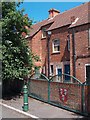
2
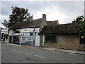
Pre-industrial Market Warsop
Market Warsop is largely a twentieth century creation though there are a few buildings from an earlier era. Most, like this cottage, have been substantially altered and are often in poor condition.
Image: © Jonathan Thacker
Taken: 21 Sep 2018
0.12 miles
3

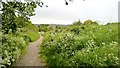
Railway line at the edge of Market Warsop
The rails now look overgrown.
Image: © Andrew Hill
Taken: 15 May 2014
0.13 miles
4
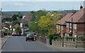
Cherry Grove, Warsop
A residential street.
Image: © Andrew Hill
Taken: 15 May 2014
0.14 miles
5
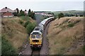
Passenger service on the Welbeck branch
The Welbeck freight branch had a rare passenger train visit from Crewe to the line on the 19th July 09. The mine at Welbeck was under threat of closure so this gave people on the charter a rare chance to visit this freight only railway branch before it shuts the following year.
Image: © roger geach
Taken: 19 Jul 2009
0.15 miles
6
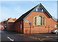
Clumber Street, Market Warsop, Notts.
The town's Methodist Church occupies a corner site formed by Portland Street (where the car is parked) and Portland Street that can be seen linking up with Sherwood Street (the B6035) ahead. Clumber Street was formerly known as Back Street.
Image: © David Hallam-Jones
Taken: 23 Jan 2016
0.15 miles
7
Rear view of shops on Sherwood Street, Market Warsop
Image: © Neil Theasby
Taken: 20 Jun 2010
0.16 miles
8
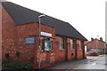
Clumber Street, Market Warsop, Notts.
With the B6035 (a.k.a. Sherwood Street) ten paces behind the photographer, this is a view of the town's Methodist Church on one side of the town centre end of Clumber Street. Clumber Street was formerly known as Back Street.
Image: © David Hallam-Jones
Taken: 23 Jan 2016
0.16 miles
9
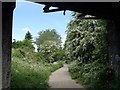
Sandy Lane from the railway bridge
Track towards Warsop from the bridge carrying a disused railway line.
Image: © Andrew Hill
Taken: 15 May 2014
0.16 miles