IMAGES TAKEN NEAR TO
Ridgeway Lane, MANSFIELD, NG20 0NP
Introduction
This page details the photographs taken nearby to Ridgeway Lane, NG20 0NP by members of the Geograph project.
The Geograph project started in 2005 with the aim of publishing, organising and preserving representative images for every square kilometre of Great Britain, Ireland and the Isle of Man.

There are currently over 7.5m images from over14,400 individuals and you can help contribute to the project by visiting https://www.geograph.org.uk
Image Map
Images are licensed for reuse under creativecommons.org/licenses/by-sa/2.0
Notes
- Clicking on the map will re-center to the selected point.
- The higher the marker number, the further away the image location is from the centre of the postcode.
Image Listing (23 Images Found)
Images are licensed for reuse under creativecommons.org/licenses/by-sa/2.0
Image
Details
Distance
2
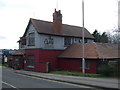
The Gate Inn, Warsop
View of the Gate Inn, Warsop, taken from top of High Street.
Image: © Ann B
Taken: 26 Mar 2003
0.12 miles
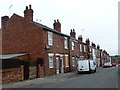
4
Askew Lane
Askew Lane, facing away from the entrance to the allotments.
Image: © James Hill
Taken: 29 Jun 2007
0.16 miles
5
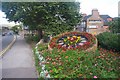
Floral display, High Street, Warsop
Floral display at the top of High Street. Also shows the A60 road through Warsop and the Black Market Bar & Live Music Venue/Warsop Workingmens Club.
Image: © Ann B
Taken: 27 Aug 2006
0.16 miles
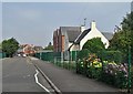
6
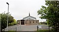
St Teresa?s Catholic Church, Market Warsop
Built in 1974. Read more at; http://www.saint-joseph.org.uk/st-teresas/
Image: © Chris Morgan
Taken: 31 May 2016
0.18 miles
7
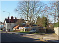
Old Sookholme Lane, Market Warsop, Notts.
When new houses where built behind this pub, this formerly rural lane - on the right of the picture - became bisected by Vale Avenue 100 metres from here. Once it became impossible to use this easterly-most end of it, this entrance/exit to and from the A60 (the main Market Warsop - Mansfield road) became a dumping ground for building debris and rubbish. Access in Sookholme Lane is now via the first righthand turning past the Ford dealership, beyond The Gate public house.
Image: © David Hallam-Jones
Taken: 28 Jan 2016
0.20 miles
8
The Gate, Pub and Dining
Formerly The Gate Inn.
Image: © JThomas
Taken: 16 Mar 2014
0.20 miles
9
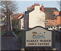
Market Warsop, Notts.
This name-sign marks the entrance to Market Warsop for those coming from the Mansfield and Mansfield Woodhouse directions. The A60 curves to the left here (not visible here but to the left of this marble memorial). Pedestrians however, can follow a footpath to the right of this sign and join the closed end of the High Street where the latter has become a cul-de-sac twenty or so paces ahead.
Image: © David Hallam-Jones
Taken: 23 Jan 2016
0.20 miles
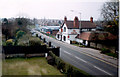
10
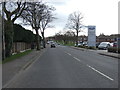
Mansfield Road (A60), Warsop
Heading south west.
Image: © JThomas
Taken: 16 Mar 2014
0.20 miles