IMAGES TAKEN NEAR TO
Oakfield Lane, MANSFIELD, NG20 0JG
Introduction
This page details the photographs taken nearby to Oakfield Lane, NG20 0JG by members of the Geograph project.
The Geograph project started in 2005 with the aim of publishing, organising and preserving representative images for every square kilometre of Great Britain, Ireland and the Isle of Man.

There are currently over 7.5m images from over14,400 individuals and you can help contribute to the project by visiting https://www.geograph.org.uk
Image Map
Images are licensed for reuse under creativecommons.org/licenses/by-sa/2.0
Notes
- Clicking on the map will re-center to the selected point.
- The higher the marker number, the further away the image location is from the centre of the postcode.
Image Listing (6 Images Found)
Images are licensed for reuse under creativecommons.org/licenses/by-sa/2.0
Image
Details
Distance
1
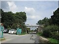
Railway bridge over Oakfield Lane, Market Warsop
Image: © Jonathan Thacker
Taken: 9 Sep 2021
0.06 miles
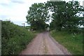
3
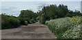
Oakfield Lane near Warsop
The track is not surfaced but used for vehicle access to a couple of properties and to farmland.
Image: © Andrew Hill
Taken: 15 May 2014
0.12 miles
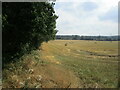
4
Fields near Market Warsop
This was from the former Lancashire Derbyshire and East Coast Railway line, which was open to freight between Shirebrook and High Marnham, when this image was taken.
Image: © Nigel Thompson
Taken: 14 Jun 2017
0.17 miles
5

Modern houses, Oakfield Lane, Warsop
New houses infilling part of an area of open land near the edge of the small town.
Image: © Andrew Hill
Taken: 15 May 2014
0.23 miles
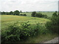
6
Oakfield Lane, Warsop
Oakfield Lane looking back towards Warsop, showing sign to footpath to Spion Kop on left.
Image: © Ann B
Taken: 5 Jun 2005
0.24 miles