IMAGES TAKEN NEAR TO
Friar Lane, MANSFIELD, NG20 0HY
Introduction
This page details the photographs taken nearby to Friar Lane, NG20 0HY by members of the Geograph project.
The Geograph project started in 2005 with the aim of publishing, organising and preserving representative images for every square kilometre of Great Britain, Ireland and the Isle of Man.

There are currently over 7.5m images from over14,400 individuals and you can help contribute to the project by visiting https://www.geograph.org.uk
Image Map
Images are licensed for reuse under creativecommons.org/licenses/by-sa/2.0
Notes
- Clicking on the map will re-center to the selected point.
- The higher the marker number, the further away the image location is from the centre of the postcode.
Image Listing (8 Images Found)
Images are licensed for reuse under creativecommons.org/licenses/by-sa/2.0
Image
Details
Distance
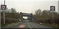
2
Autumn sown crop near Meden Farm
The railway bridge over Forest Road near the centre of the picture.
Image: © Jonathan Thacker
Taken: 30 Jan 2022
0.06 miles
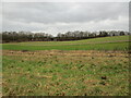
4
Grass field off Forest Road
The embankment of the former Welbeck Colliery branch railway closes the view.
Image: © Jonathan Thacker
Taken: 30 Jan 2022
0.10 miles
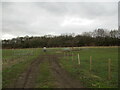
5
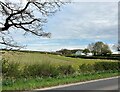
Farmland near Market Warsop
Fields adjoining Meden Farm and the Blakeley Hill Plantation pictured from a narrow footpath by the B6035 Road.
Image: © Jonathan Clitheroe
Taken: 19 Apr 2022
0.15 miles
6
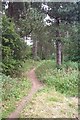
Path in Woods
Path in the woods near Coach Road, Warsop.
Image: © Ann B
Taken: 31 Jul 2005
0.18 miles
7
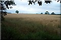
Wheat Field
Field of wheat at the side of Coach Road, Warsop.
Image: © Ann B
Taken: 31 Jul 2005
0.18 miles
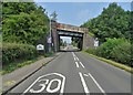
8
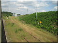
The former Welbeck Colliery railway Junction
This was from the former Lancashire Derbyshire and East Coast Railway line, which was open to freight between Shirebrook and High Marnham, when this image was taken.
Image: © Nigel Thompson
Taken: 14 Jun 2017
0.24 miles