IMAGES TAKEN NEAR TO
Sherwood Street, MANSFIELD, NG20 0HQ
Introduction
This page details the photographs taken nearby to Sherwood Street, NG20 0HQ by members of the Geograph project.
The Geograph project started in 2005 with the aim of publishing, organising and preserving representative images for every square kilometre of Great Britain, Ireland and the Isle of Man.

There are currently over 7.5m images from over14,400 individuals and you can help contribute to the project by visiting https://www.geograph.org.uk
Image Map
Images are licensed for reuse under creativecommons.org/licenses/by-sa/2.0
Notes
- Clicking on the map will re-center to the selected point.
- The higher the marker number, the further away the image location is from the centre of the postcode.
Image Listing (9 Images Found)
Images are licensed for reuse under creativecommons.org/licenses/by-sa/2.0
Image
Details
Distance
1
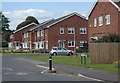
Modern houses, Oakfield Lane, Warsop
New houses infilling part of an area of open land near the edge of the small town.
Image: © Andrew Hill
Taken: 15 May 2014
0.14 miles
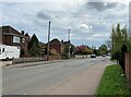
2
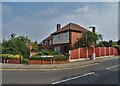
House on the corner - Market Warsop
Where Sherwood Street meets Top Sandy Lane
Image: © Neil Theasby
Taken: 11 Aug 2020
0.14 miles
3
Sherwood Street in Market Warsop
The B6035 Road looking away from the town centre.
Image: © Jonathan Clitheroe
Taken: 19 Apr 2022
0.16 miles
5
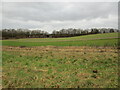
Autumn sown crop near Meden Farm
The railway bridge over Forest Road near the centre of the picture.
Image: © Jonathan Thacker
Taken: 30 Jan 2022
0.21 miles
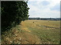
6
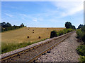
Railway and field
A railway passing by a harvested field on Mount Pleasant in Warsop.
Image: © James Hill
Taken: 10 Aug 2007
0.21 miles
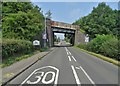
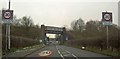
7
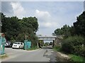
Railway bridge over Oakfield Lane, Market Warsop
Image: © Jonathan Thacker
Taken: 9 Sep 2021
0.22 miles